Lake Mansarovar is located in Ngari Prefecture of the Tibet Autonomous Region of China. It is located in the far western region of Tibet, situated close to the borders of India and Nepal. At an elevation of 4,588 meters (15,043 feet), Mansarovar is at a distance of about 20 kilometers (12.5 miles) southeast of Mount Kailash, the sacred mountain, and at the base of the mountain.
The western border is also along a part of the Indo-Tibetan border near Lipu Lekh Pass, and there is a collection of pilgrimage trails on the eastern side of the Lake in this key tri-junction area of Tibet, India, and Nepal.
There is deep spiritual significance of Mansarovar Lake to Hindus, Buddhists, Jains, and Bon people. In its stunning setting, West of Mount Kailash, and at the borders of India and Nepal, it has become an important pilgrimage site and a geographically significant site.
This article aims to locate Lake Mansarovar on a map for context, with its geographical ltural significance. The freshwater lake sits at an altitude of over 4,500 meters and is considered one of the holiest and highest lakes in Asia. Given that the lake is found within the western tri-junction border area, many transit routes allow access to the lake from different countries. You can transit to the lake from either Nepal, India, or Tibet.
The lake's crystal blue waters add to the spirituality of this lake, and it is said that bathing in the lake during the ritual will purify you of your sins. Furthermore, the data provides a map of the location of Lake Mansarovar (and how it relates to Mount Kailash, the other mountain ranges that surround the lake, and the trek routes of the many pilgrims each year) that closes the distance between you as a pilgrim, trekker, geographer, etc., and an amazing place in the Himalayas.
This geographic overview prepares the reader for an additional exploration of the cultural and spiritual importance of Lake Mansarovar and its setting. Moreover, understanding where Lake Mansarovar is located adds contextual depth to the sense of sacredness and to its significant position at the intersection of some of Asia's deeper spiritual legacies.
Where Exactly Is Mansarovar Lake Located on the Map?
Latitude: approximately 30° 40′ N (or 30.65° N)
Longitude: approximately 81° 28′ E (or 81.45° E)
Elevation: about 4,588 m (15,043 ft) above sea level.
Turning to the question of the location of Lake Manasarovar on the map, the actual response would be as follows: it is in the south-western part of the territory of the Tibet Autonomous Region (China), in Ngari Prefecture, which is the Burang County, also referred to as Purang.
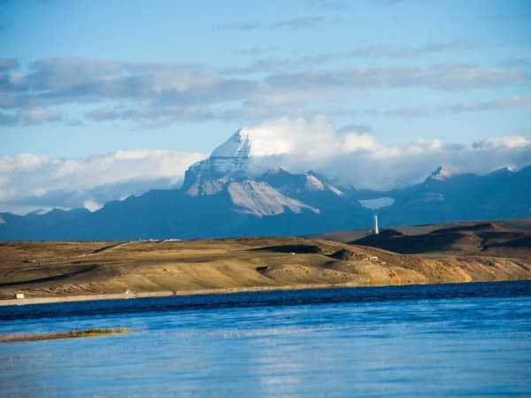
If you look at a map, you will see it is high up on the Tibetan Plateau at about 4,600 metres above sea level. From the map, you can see that Lake Manasarovar is located just south of the holy Mount Kailash (also in Ngari Prefecture).
In fact, according to the road map, the lake is about 47 – 50 kilometres south of Mount Kailash. Geographically, it is located close to the Western trijunction of China, India, and Nepal, meaning on the map it is located relatively close to the border line where the three countries meet.
On many maps, the lake is indicated at around 30.65 °N latitude and 81.45 °E longitude.
If you look at a regional map, Lake Manasarovar is just south of the top of Mount Kailash (about thirty kilometers away), which is slightly north of it.
The lake is located at the westernmost location of Tibet, with the India–Nepal–China tri-junction area a little bit southwest and south of the lake.
That should give a clear map reference: the furthest west section of the Tibetan Plateau & by the Himalayan boundary.
If you are searching for a map and you want to mark Lake Manasarovar, you will see it is in the section of Tibet that is farthest away from major cities. On a map of China, you can find the Tibet Autonomous Region, go to the western section (the region of Ngari Prefecture), and determine the coordinates (30.65 N; 81.45 E), which will give you a spot-on location of the lake.
The map will also show the next nearest international border lines in India and Nepal, which reinforce how remote and important this location is.
From a limited viewpoint of the international border, south of the lake is the Indo-Nepal border region while on both sides of the lake are the larger plateaus of western Tibet.
Exact Location
Feature
Detail
Country / Region
Tibet Autonomous Region, People’s Republic of China
Prefecture
Ngari Prefecture
County
Burang (Purang) County
Approximate Coordinates
~ 30.65° N latitude, ~ 81.45° E longitude
Elevation
~ 4,585–4,600 m above sea level
Relation to Mount Kailash
About 47–50 km south of Mount Kailash
Border context on map
Near the western trijunction of China-India-Nepal
Where is Lake Mansarovar Located? Quick Location Guide
Category
Details
Official Name(s)
Lake Mansarovar (also spelled “Manasarovar”) – in Tibetan: Mapam Yumtso (玛旁雍错).
Country / Administrative Region
The lake lies within the Tibet Autonomous Region of the People’s Republic of China.
Prefecture / County
Located in Ngari Prefecture (阿里地区), specifically in Burang County (布朗县) near the western edge of Tibet.
Nearby Landmarks
• Sits at the southern foot of Mount Kailash (Kang Rinpoche) in the Himalayas.
• Also close to the salt lake Rakshas Tal (Rakshastal), which lies just adjacent.
Latitude / Longitude
Approximate coordinates: near to 30° 40′ N latitude, near to 81° 30′ E longitude. (Some sources give near to 30.65 °N / 81.45 °E)
Elevation (Altitude above Sea Level)
near to 4,590 m (around 15,060 feet) above sea level. Some sources quote near to 4,583 m or near to 4,556 m.
Surface Area / Shape / Size
• Surface area: around 320 km² (120 sq mi) in many sources.
• Other sources list 412 km².
• Shape: roughly round or pear-shaped (wider north, narrower south) in descriptions.
Circumference / Perimeter
Approximate circumference: near to 88 km (around 55 miles).
Maximum Depth
Roughly up to near to 90 m (around 300 ft) in several sources.
Hydrology / Outflow
The lake is freshwater. It is connected via a channel (Ganga Chhu) to the adjacent salt lake Rakshas Tal. Some major Himalayan rivers originate near its region.
Geographic Context
• Located on the high Tibetan Plateau, in a remote, sparsely populated region of western Tibet.
• Southwest of Tibet, near the trijunction area of China, India and Nepal.
Access / Distance to Notable Places
• About 2,000 km from Lhasa (Tibet’s capital) according to some tourist descriptions.
• Often reached via pilgrimage routes through India/Nepal into Tibet and then to the lake.
Administrative & Border Issues
The lake lies very close to international borders (China-India-Nepal tri-junction), which influences travel routes, permissions, and logistics.
Where is Mansarovar Lake in the Map of India? – Many Believe It’s in India, But It’s Not
Among Indian folk, when the word Mansarovar rings, it invokes images of a holy lake situated somewhere deep in our shores, but the reality is so very different. India does not have Lake Manasarovar. It is located in the Tibetan Plateau, in the Tibet Autonomous Region of the People's Republic of China.
Why the Confusion?
The spiritual connection that the lake enjoys with India is one of the reasons why it is confusing. It belongs to the popular Kailash-Manasarovar Yatra pilgrimage that is undertaken by a large number of Indians through the Indian state of Uttarakhand or Sikkim, Nepal, or via the Lipulekh/Nathu La.
Since there are so many Indian pilgrims traveling the routes that originate in or go through India, and where the lake is so spiritual to the Indian religious tradition, the mental map tends to locate the lake within India. But it falls within China as a geopolitical and geographical territory.
Exact Location & Geography
The following are the major facts regarding its real location:
This lake is located in Ngari Prefecture (Burang County), western Tibet.
Roughly 4,590 m (15,060 ft) above sea level, it is among the highest freshwater lakes in the world. Furthermore, it is situated around 20-30 km southeast of Mount Kailash, which is also near the borders of Tibet, India, and Nepal.
So What Does That Mean for India?
Although the lake is not Indian territory in a political sense, it is firmly entrenched in Indian culture, faith, and pilgrimage. Hindus believe that bathing or taking a dip in Lake Manasarovar cleanses sins, and therefore, the yatra is arranged with the Indian authorities.
It also implies that you will find that in the maps of India, Lake Manasarovar is not supposed to be in the national boundary; it belongs legally and geographically to the Tibet Autonomous Region of China.
Understanding the Exact Location of Mansarovar Lake on Different Map
Mansarovar Lake on the Map of Asia
Latitude & longitude: near to 30.7° N, 81.5° E.
Elevation: near to 4,585 m above sea level.
Located in Burang (Purang) County, Ngari Prefecture, Tibet Autonomous Region, China.
Just north of the Himalayas, and east of the India–Nepal border.
Looking at a larger map of Asia, the lake is situated near the triple-border area where China (Tibet), Nepal, and India are closely aligned. It is approximately 4,585 m (near to 15,040 ft) above sea level, classifying it as one of the highest large freshwater lakes in Asia.
On a somewhat larger, regional Asian map, the lake area is located to the west of much of high-mountain Nepal and to the north‐east of Uttarakhand in India, but it is still entirely situated within that of Tibet (China) thus outside of political India. At this level of mapping, its location is depicted as part of the high altitude “roof of the world” area held above the Himalayan and Trans-Himalayan mountain chains, not in the plains or lower hills of South Asia.
From the Asian cartographic standpoint, major rivers (such as the Indus River, Sutlej River, Brahmaputra River, and the Karnali River) originate from the wider region surrounding the lake, thus substantiating its significance in continental geography.
Thus, on a map of Asia, the lake appears as a high-altitude jewel in western Tibet, apart from the land mass of India (though culturally connected) and clearly beyond the borders of India, as many might assume otherwise.
Mansarovar Lake on the World Map
Location of Lake Mansarovar in Google Earth
Coordinates: near to 30.5° N, near to 81.3° E.
Elevation: near to 4,588 m above sea level.
Region: Western Tibet, China (Ngari Prefecture / Burang County area).
Proximity within Asia: The northern edge of both the Himalayas and the Tibetan Plateau is located in China's far western region, close to the border with India and Nepal.
The lake, Lagoon of Manasarovar (also stylized Lakes Mansarovar), is located high on the Tibetan Plateau, in the Tibetan Autonomous Region of the far-western part of China.
On a world map, you can find it within approximately 30° 33′ N to 30° 47′ N latitude and 81° 21′ E to 81° 36′ E longitude.
It sits north of the western trijunction of the borders of China, India, and Nepal.
The Lagoon of Manasarovar sits at about 4,588 m (15,060 ft) above sea level, among the highest large freshwater lakes on the globe.
It is roughly situated at an area of 320km² and has a set of shores with a perimeter of about 88 km.
Regarding the world map and the continent of Asia:
It is situated in Asia, to the north of the Himalayan mountain range, in an area known as the Trans-Himalaya of western Tibet.
On a map of Asia, it will be seen very near to the westernmost part of China, and relatively near Nepal, and beneath India in the state of Uttarakhand, if you draw a line south.
It is quite remote, but it is also strategically located at the watershed of multiple major Asian river systems (Indus, Sutlej, Brahmaputra, and Karnali) that all begin in that vicinity.
Mansarovar Lake on the Map of Tibet
Location of Kailash Mansarovar Lake in Tibet Map
It lies just south of the Western Himalaya Mountain range and north of the region where the borders of India and Nepal meet.
It is in the western part of Tibet, Ngari Prefecture, Burang County.
Altitude: approx. 4,585 m.
Coordinates: about 30.69° N, 81.48° E.
According to the Tibetan maps, it is near the Kailash-Manasarovar pilgrimage routes.
Lake Manasarovar is in the western part of the Tibet Autonomous Region (China), Burang County, Ngari Prefecture. On maps of Tibet, it is depicted just south of the northern edge of the Himalayas, north of the region where the borders of China, India, and Nepal meet, and a bit northwest of where the three borders converge.
The lake is at a stunning height of about 4,585 m (15,040 ft) above sea level; thus, it is among the highest large freshwater lakes of the world.
Lake Manasarovar can be found at roughly 30.687° N, 81.479° E.
On a map of Tibet, Lake Manasarovar appears in a remote and sparsely populated part of the plateau far removed from the major cities like Lake Manasarovar is situated in an isolated part of the Tibetan Plateau and, based on map representation and geography, appears remote when compared to population centers, such as Lhasa, about another 800 km east.
The area surrounding the lake is high altitude, cold, remote, and the terrain is rough, with mountain ranges and high plains nearly making up the entire border of the lake.
As part of the Tibetan Plateau, this site is a significant geographic sight on any map of Tibet. It continues to be cited on maps of Tibet and generally has its own name and cluster of geography in the extreme western locality of the Tibetan Plateau, generally named "Malabar."
Due to its high altitude and remote location, it is also generally characterized as an important geographic site and/or a significant spiritual site in maps of Tibetan geographic sites.
The proximity of the pilgrimage site of nearby Mount Kailash (also cited on maps) lends significance to the region. Also on maps of the lake are the pilgrimage access roads/approaches to the lake, permitting access from the Darchen access point and other access methods.
Mansarovar Lake on the Himalayan Map
Manasarovar bears a prominent title on the map of the Himalayan region. It is only a little to the north of the main Himalayan chain and to the south of the interior Tibetan elevated areas.
It is also close to the sacred Mount Kailash (more than 6,600 m above sea level), which places Lake Manasarovar in the greater geographic and hydrologic high-elevation area of the Himalayas or Tibetan plateau.
And, the lake itself is close to the main sources of rivers in the Watershed of the Himalayas, the Indus River, Sutlej River, Brahmaputra River and Karnali River.
A closer look at a map of the Himalayan region will reveal the Manasarovar lake, which is situated south and west of Mount Kailash, and which is incorporated into a rugged alpine landscape.
On even high-resolution maps, it is clear that Manasarovar is a freshwater lake because of the territory around the lake and the distinctive shape of the lake itself.
The pilgrimage mapping representing access routes is in and around the lake, thereby pointing out the location of the lake and Mount Kailash in the altitudinal geography of the Himalayas.
In comparison with the elevation of the lake, and its location in the Himalayas:
Manasarovar is under the direct influence of the alpine climate, with chilly season winds, and the lake is likely to be covered with snow at altitude, may have occasional seasonal freezing of the lake and thawing up.
The map overlays indicate sharp climbs to the snowy ranges of the Himalayas. The plateau of the north of Manasarovar is also elevated and is relatively flat with irregularities / topographical features.
Manasarovar is given a special place on a map of the Himalayan region. It is above the main Himalayan chain, and south of the inner Tibetan highlands. It is also near the holy Mount Kailash (6,600m high), and the lake is a part of the larger Himalayan high-altitude system.
The region of the lake, which is close to the big river sources (Indus, Sutlej, Brahmaputra, Karnali), is also a strong indication of its geographical importance within the Himalayan watershed.
Looking closely at a map of the Himalayas:
Manasarovar is presented in the form of a large freshwater body that is located south-west of Mount Kailash and is surrounded by rugged terrain in the Alps.
The shape of the lake and the ridges surrounding it cause it to be seen in high-resolution maps of the area.
The pilgrimage maps used to access the routes to the pilgrimage locations reveal the physical geography location of the lake, by circling around and close to the lake.
Considering its elevation and location in the Himalayas:
The lake is prone to alpine weather, whereby there are cold winds, the possibility of snow cover at high altitudes, and seasonal freezing/melting of the lake.
In the maps of the overlay, one may observe that the land between Manasarovar and the Himalayan mountains rises sharply, and that, to the north of it, the plateau land remains relatively low though it is very high.
Mansarovar Lake on the Map of the Region
Lake Manasarovar is located in the extreme western region of the Tibet Autonomous Region (China), Ngari Prefecture, Burang County. With a latitude of 30.687deg N and a longitude of 81.479deg E, it is approximately 4,585m above sea level.
Thus, it is one of the largest freshwater lakes in this area. When you look at the map of the Ngari region/western Tibet, there is a large bluish body of water called Lake Manasarovar, just south of Mount Kailash.
Regional Features on the Map
You will find a lake on regional maps named Manasarovar, right to the south-west of Mount Kailash, which is a great mountain in the Ngari region.
It is situated on the northern border of the main Himalayan range and the southern border of the Tibetan Plateau, which implies that on the maps, the landscape of the area in question is marked by the shift from the high plateau to the steep mountainous terrain.
The lake borders the border region between China and Nepal, as well as India. On the maps, the lake is only seen just above the western end of the Himalayan chain and the three-country border region.
Mansarovar Lake location in Relation to the India–Tibet Border
Relative to the India-Tibet (China) border, the lake is further north of the border between India and Tibet, and is somehow further west of the tripoint of India, Nepal and China (the so-called tripoint). It is said to be north of the western tripoint of the boundary between China, India and Nepal.
Practically speaking, in the case of an Indian state, like Uttarakhand, when you go northwest across the Himalayan border, you would find yourself in Tibetan land, and this western expanse is where Manasarovar is.
Due to this reason, in most pilgrimage route maps, the path to India goes through passes to Tibet and then off to the lake.
Thus, when placing the lake on a map showing the border:
The lake falls within the Tibet Autonomous Region of China (not India).
It is only tens of kilometres north of the Himalayan crest/border area, as opposed to being well within central Tibet.
It borders on the west of Nepal and Tibet, as opposed to being nearly north of central Nepal.
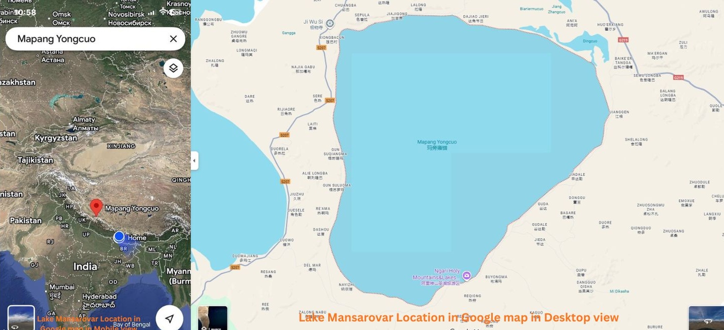
Where Can You Find Kailash Mansarovar on Google Maps?
Location of Lake Mansarovar as per Google maps
In case you want to have a voyage with Google Maps on the sacred land of Mount Kailash and Lake Mansarovar, then follow the following instructions:
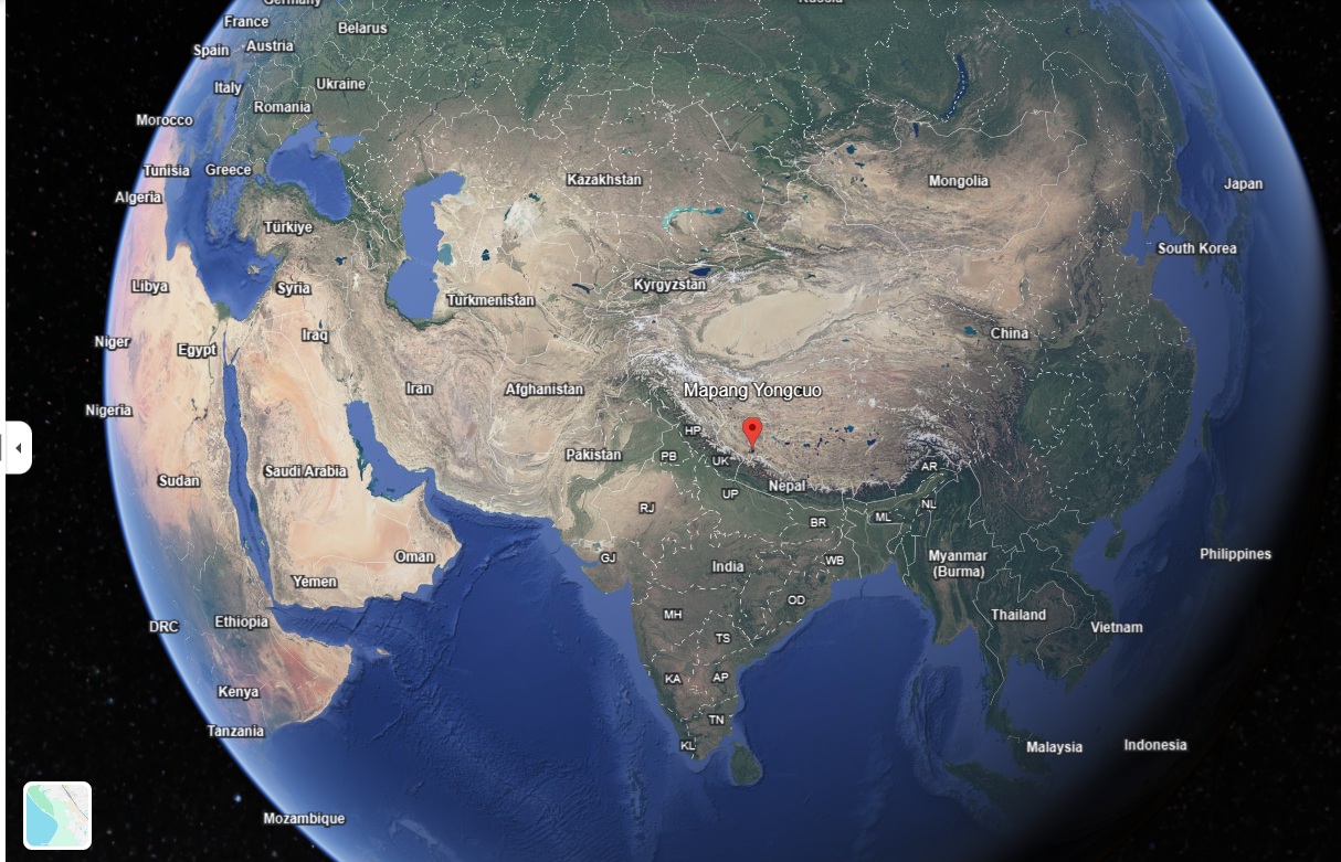
Go to Google Maps and search for either Mount Kailash, Tibet or Lake Mansarovar, Tibet. Mount Kailash has a latitudinal value of about 31.0674 °N and a longitude of 81.3119 °E.
Lake Mansarovar is located in the same region, the far west of the Tibetan Plateau, the Ngari Prefecture of the Tibet Autonomous Region, China.
How to zoom in & what to expect?
After that, when you have found the rough point, choose the Satellite view mode of Google Maps: you will realise a rough and high-altitude landscape with snow and glaciers. The area is so remote that you will not find a high concentration of roads and big towns around.
The lake is a glittering, wide pool in contrast to the hard mountains; the mountain itself is quite steep on the plateau. Also, notice the closeness to the border area of China (Tibet) and India/ Nepal - the mountain is right north of that trijunction.
The view of the region that this map vindicates is the sense of its remoteness and theatricism, of the absence of villages and of any but high-mountain roads and paths.
On Google Maps, one can also change to the Terrain or Relief layer to see the elevation changes, and in that way, one can grasp how the lake and mountain protrude out of the plateau and the Himalayas. The map of this area created by Google depicts the mountain in the entire context of the Gangdise (Kailash) Range of the Trans-Himalaya.
Directions & tips for navigation
Search by direct coordinates to get the most accurate pinpoint using Google Maps.
Use Satellite and Terrain layers for the best view of topography.
Zoom out a bit to grasp the border context (China-India-Nepal) and then zoom in to explore features like the lake’s shoreline or mountain slopes.
Be aware that due to its remote altitude and political sensitivity, some map data may be less detailed.
Mansarovar lake Address
Street Address or P.O. Box
Lake Manasarovar is located in the Ngari Prefecture of the Tibet Autonomous Region (Burang County) of China. Being a far-flung area, it does not have a physical street address or a P.O. Box. Nevertheless, the latitude and longitude general coordinates are around 30.9833 °N and 81.3833 °E, respectively.
City or Town
The closest town to Lake Manasarovar goes by the name Purang (Burang), which is about 20 kilometres southeast of the lake. Burang is one of the important administrative and commercial centres in western Tibet.
District, Subdistrict or Locality.
Lake Manasarovar is located in Burang County, which is located in the Ngari Prefecture of the Tibet Autonomous Region. The region is also famous in terms of religious and natural beauty, which has drawn pilgrims and travellers from all over the world.
Province, State, or Region
The lake is found in the Tibet Autonomous Region (TAR) in China, which is in the Ngari Prefecture. High altitude landscapes characterise this region, and this is a very important aspect of the Tibetan cultural and spiritual heritage
Postal Code
Burang County is under the post code of 859500. Nonetheless, the remote location of the lake might mean that there is no direct postal service in that place.
Country
Lake Manasarovar is found in the People's Republic of China in the Tibet Autonomous Region. It is close to the western trijunction of China, India and Nepal, thus an important geographical and cultural landmark.
Mansarovar Lake Is in Which Country? The Truth: It’s in China, Not India
lake mansarovar view
Lake Manasarovar is not in India as it is a misconception; it is in the Tibet Autonomous Region of the People's Republic of China. The lake is located in the Ngari Prefecture of west Tibet.
Although there are numerous stories that associate the lake with Indian mythology, the administrative and geographical address of the lake is clearly within Chinese jurisdiction.
Why has this confusion continued to persist?
The confusion is caused by the fact that Lake Manasarovar is considered holy in India's religious traditions (Hinduism, Jainism) and is very close to the border region between India, China and Nepal.
It is mistakenly sometimes put in India due to its cultural connections and its connection with the pilgrimage trails from India. But in reality, Tibet has ruled over the region for centuries and now it is being ruled by China.
Location in a nutshell
The lake is located at the base of Mount Kailash, in Burang (or Purang) County, Ngari Prefecture, Tibet. It is located approximately 4590 m above sea level and includes an area of approximately 400+ km2.
The lake is still firmly inside Chinese-administered territory, despite it being close to the "western trijunction" of China, India and Nepal.
Lake Manasarovar is one of the highest lakes in Asia with fresh water and spiritual significance.
Although it is located in China, it doesn't devalue its religious aspect to Indian pilgrims but brings with it its own administrative process and jurisdiction which is under Chinese control.
Identifying the country is important for:
Pilgrimage logistics and necessary visas (because you are entering into Chinese territory).
Geography knowledge and responsible tourism.
Himalayan geopolitics: understanding the past and present of this complex border area
So henceforth if anyone asks, which country is Lake Manasarovar in? The answer is China (Tibet Autonomous Region) and not India.
Know the Detailed Geographic Setting of Lake Mansarovar in 2026
Coordinates and Elevation of Lake Manasarovar
The lake lies at roughly 30.65° N latitude and 81.45° E longitude. In terms of elevation, sources converge on an altitude of about 4,590 m (15,060 ft) above sea level.
Some slightly different figures exist (e.g., 4,583 m) but all indicate the lake sits very high on the Tibetan Plateau.
Administrative Region – Prefecture, Province, Country
Administratively, Lake Manasarovar is located in the following hierarchy:
Country: People’s Republic of China.
Province/Autonomous Region: Tibet Autonomous Region (TAR).
Prefecture: Ngari Prefecture (西藏自治区阿里地区).
County: Burang (Purang) County in Ngari Prefecture.
Thus, while often culturally associated with India and Nepal through pilgrimage, the lake falls under Chinese jurisdiction.
Nearby Geographic Landmarks
One of the most significant nearby landmarks is Mount Kailash (6,638 m) which lies just to the north of Lake Manasarovar.
The lake lies near the “western trijunction” region where the borders of China, India and Nepal meet (though the precise tripoint is located slightly to the south of Mount Kailash).
Another nearby lake is Lake Rakshastal (salt-water), just to the west of Manasarovar, connected by a channel.
The geography around is remarkable: high plateau terrain, glaciated mountains on the periphery, and the lake basin itself shaped by tectonic and glacial processes.
Surface Area, Depth and General Physical Features
Surface area: Estimates vary slightly, but most reliable sources list around 410–412 km². Some older or simpler sources put it at near to 320 km².
Maximum depth: Around 80–90 m is cited in recent literature (e.g., 81.8 m).
Average depth: Some hydro-geological studies note an average depth of near to 46 m.
Shape and form: The lake is described as somewhat pear-shaped (wider in the north, narrower in the south).
Water quality & clarity: It is a freshwater lake (unusual at this altitude) and noted for high transparency—reports suggest you can see up to 14 m down.
Hydrology: Fed mainly by glacial meltwater and precipitation; the basin lies between the Gangdise Mountains (Trans-Himalaya) and the Himalayas.
Altitude effects: At near to 4,590 m, the lake’s climate is very cold, with short summers and long winters; it remains frozen much of the year.
In Which State Is Mansarovar Lake Situated?
Many pilgrims from India and Nepal come to Lake Manasarovar, as it is in the same pilgrimage area as Mount Kailash. Because of that strong Indian and Nepali travel link, it is sometimes assumed that the lake must belong to an Indian 'state' (for example, Uttarakhand, Sikkim or Himachal) or a province of Nepal.
But this is not the case. In fact, Lake Manasarovar is located in the territorial boundaries of the Tibet Autonomous Region of the People's Republic of China, under the administrative jurisdiction of Burang County of Ngari Prefecture.
Because China's administrative divisions are not the same as the "state" system as found in India or the provinces of Nepal, it's inaccurate to say that Lake Manasarovar is in an Indian state or Nepalese province. Instead, it is governed in a "prefecture" and "county" in Tibet. In other words, it is neither in an Indian state nor in any Nepali province.
The lake has an elevation of about 4,583 - 4,588 metres above sea level.
It is situated at a distance of around 20-30 km southeast of Mount Kailash.
Administratively, it is in China's Tibet Autonomous Region: in Burang County, Ngari Prefecture.
Because of its location, the proper phrase isn't "which state" (as one would say in India or Nepal), but rather "which autonomous region/prefecture/county" in China.
Thus, the confusion: People who have familiarity with Indian geography expect "state" labels; because the pilgrimage has such strong ties in India and Nepal, some assume it must be part of India or Nepal.
But formally and geopolitically, the lake is inside China (Tibet region) and not in any of the internal states of India or Nepal.
Mansarovar lake lies in which Range?
The lake is geographically situated in the mountainous terrain of the Gangdise Shan range (also known as Kailas Range), which is a subset of the larger system of the Transhimalaya.
The Gangdise Shan is a chain of mountains that traverses western Tibet and creates one of the longest mountain chains of the Transhimalaya north of the main Himalayan crest. Mount Kailash is in this range.
Since Lake Manasarovar lies at the foot of Mount Kailash, it has taken over the mountain range title of the area. Then, when one questions, in which area does Lake Manasarovar fall, the right answer is that it falls in the Gangdise Shan (Kailas Range) of the Transhimalaya.
Most people may believe the Himalayas, but the lake is a part of the Transhimalayan region (Gangdise Shan) and not of the Himalayan region.
Know Fully The Area of Mansarovar Lake
Location & Elevation
Lake Manasarovar (alternatively Mansarovar) is located in the extreme western region of the Tibet Autonomous Region (China) in Burang County of Ngari Prefecture. The lake has a height of approximately 4,590 m ([15,060 ft) above sea level.
Area & Dimensions
The lake is estimated to be 412 square kilometres. A few other sources provide less, about 320 km2. In other descriptions, the lake has a circumference of approximately 82 km.
Surrounding Geography & Nearby Places
The lake is situated on the southern slope of Mount Kailash, 20-30 km. The area around is isolated, and the topography is at an elevated level, the peaks snow-white and the streams of glaciers feed the lake.
Close to the settlements (in an extremely rugged and remote usage) is the small base camp town of Darchen, the point of pilgrimage launches. The location is close to the trinity of China, India, and Nepal, in terms of national borders.
Significance & Rivers
In addition to the scenic beauty, the lake has a religious significance to the Hindu, Buddhist, Jain as well and Bon religions. It is also hydrologically important: a number of large Asian rivers start in the area around the lake.
Access & Surrounding Area Overview
Due to its remote location and high altitude, visiting the lake is accompanied by a lot of travel and acclimatisation. Nepal (or some areas of India) is the starting point of many pilgrimage routes, which cross into Tibet. The region surrounding the lake is lightly inhabited, rough and dominated by mountainous landscape as opposed to cities.
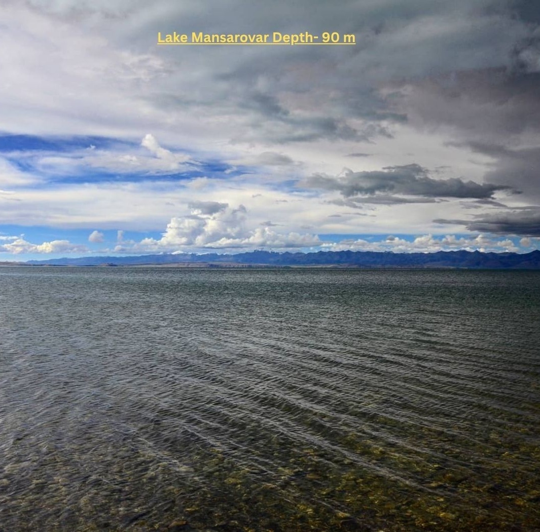
How Deep Is Mansarovar Lake?
Lake Mansarovar Depth
Concerning the depth, the figures are slightly different across sources. A single scientific data point produces the highest depth of 81.8 metres and an average depth of 46 metres. In other accounts, especially those intended to be read by visitors, there can be a depth of about 90 metres (approximately 300 feet) or even approximately 100 metres (330 feet) in certain situations.
Due to the diverse topography, the glacial-based basin and the remote conditions of measurements, the depth range displays a degree of uncertainty. To put it in short, the lake is quite deep as far as it is a high-altitude lake, as deep as 80-100 metres in its deepest part.
This significant depth, combined with the obvious glacial meltwater, serves to explain the great clarity of the lake as well as the deep shades of blue-green that can be seen along the banks of the lake.
Mapping Lake Manasarovar
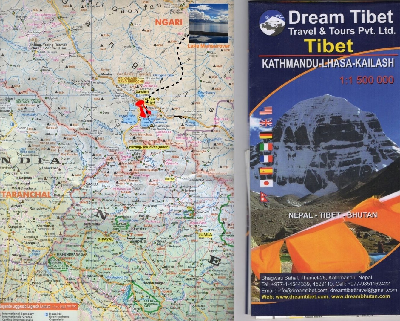
Historic maps vs modern maps
The historic maps of Lake Manasarovar are often based on early expeditions and surveys made during the colonial period (such as a map dated 1907). Such maps are likely to depict rough outlines of the lakes, the prominent peaks, and the paths used by the previous explorers, but they can be erroneous in size, specific boundaries, or topography.
Modern maps, on the other hand, have the advantages of satellite imagery, GPS, a more detailed topography and clearer administrative boundaries. As an illustration, the current map layers of online travel have the precise position of the lake in Ngari Prefecture, Tibet Autonomous Region, China.
Old maps are an interesting source of insight into what the area used to be like, including the routes pilgrims or explorers followed and the names that were applied in earlier times.
Newer maps, on the other hand, are a reliable source of geolocation, elevation, terrain colouring, and political or boundary divisions. It was important to see the differences in order to comprehend the way cartography and border knowledge have changed.
How to read a map of Lake Manasarovar region?
To go through a map of this area, it is a good idea to follow a couple of steps:
Find the location of the lake: The lake is located in Burang (Purang) County, Ngari Prefecture, Tibet Autonomous Region, China.
Check orientation and scale: Check north-arrow, scale bar, contouring/terrain shading (because this is a high-altitude area).
Topography and altitude: Search in the shading line/contour line that shows high mountain ridges surrounding the lake (e.g. Mount Kailash by the side of the north of the lake).
Routes and access points: On pilgrimage or travel maps, the routes of e.g. Nepal or India via passes are depicted. Knowing these will make the map oriented according to real-life travelling.
National border (China-India-Nepal trijunction region) and administrative boundaries: The national border will be indicated on the modern map, as well as the prefecture/county borders.
With those steps, you may read simple travel maps and elaborate topographic or political maps of the region of the lake of Manasarovar.
Map Features and interpretation (rivers, passes, borders)
Rivers: The area around the lake of Manasarovar is also of hydrological importance. Despite the fact that the lake is freshwater, one of its outlets is the passage into the salt lake Lake Rakshastal. Furthermore, the headwaters of such big rivers as the Indus, Sutlej and Brahmaputra lie in the larger area.
Mountain passes: Mountain passes are pointed out on pilgrimage and travel maps (such as the route between India and Lipulekh Pass). These are indicated on maps in terms of altitudes and points of connection.
Borders and administrative lines: Maps typically depict the international border between China (Tibet) and India/Nepal, as well as internal borders, e.g. prefecture borders (Ngari). The awareness of these will assist you in knowing the jurisdiction and travel laws.
Topographic relief: Here, the terrain with peaks all over and the glacier areas are important in this highland (Lake Manasarovar is located at a height of approximately 4,588 m above sea level).
Pilgrimage route overlays and kora circuits: The paths take the form of the kora circuits around Lake and Mount Kailash, or even the kora circuits. These can be shown in the form of loops or dotted lines.
By interpreting all these characteristics, you can no longer view a static map but can see the terrain, challenges of the journey and political geography and hydrological importance surrounding Lake Manasarovar.
Map-based travel routes (entry & exit)
Border and Access Context
Proximity to India, Nepal and China borders
It is a lake located in the Western region of the Tibet Autonomous Region in China (Burang County, Ngari Prefecture). It lies very near the tri-junction area of China, India and Nepal - even though it is within Chinese territory.
Due to that, the entry points usually begin with India or Nepal and cross China (Tibet) to access the lake. For example:
From Nepal: The route goes via Kathmandu → Rasuwagadhi (or Kerung/Kodari) border crossing into Tibet → onwards to Saga → Lake Manasarovar.
From India: There are official pilgrimage routes via the Lipulekh Pass in Uttarakhand or the Nathu La in Sikkim.
Passes and checkpoints (for pilgrims/travellers)
Lipulekh Pass (Uttarakhand, India) – a special path that Indian pilgrims have to follow in entering Tibet during this Yatra.
Nathu La Pass (Sikkim, India) – this is another pathway of the Indian pilgrims.
Rasuwagadhi/Kerung (Nepal‐Tibet border) – the overland route to Kathmandu is used by Nepalese pilgrims and other pilgrims.
Besides these border crossings, even after entering Tibet, one must have special permits (e.g., the Aliens Travel Permit) to continue to the restricted part of Tibet, Western Tibet.
Road and trail access as shown on maps
When looking at maps of access to Lake Manasarovar, you will typically see:
Motorable roads: There is the national highway G219 in Tibet, between Saga and Lake Manasarovar. This highway is a distance of approximately 496 km long between Saga and Lake Manasarovar.
Border-to-entry routes Kathmandu (Nepal) Kathmandu: You will first drive/hike to the border, cross over into Tibet and then drive on the Tibetan roads to the lake.
Hiking paths along the lake and on the Kailash mountain: Once having arrived at the area by road, much of the track uses foot travel (e.g. the Kora around the mountain) where blocks on the map represent a dotted line or the line of a hiking path.
Checkpoints and acclimatisation: Maps usually show important towns (e.g., Darchen, Taklakot/Burang) where travellers pause to buy permits, or to acclimatise.
When interpreting such maps:
Begin with your entry point (Nepal border or Indian pass).
Take the road system into the Tibetan land (e.g. via Saga, and along G219).
Determine the last leg to go to Lake Manasarovar (usually smaller roads or tracks).
Then find base camp towns (e.g. Darchen) for the trekking part.
How To Reach Lake Mansarovar Location?
Route 1: Overland from Kathmandu – Via Nepal–Tibet Border
In Kathmandu (Nepal), you can drive or bus to the Nepal-China (Tibet) border at Gyirong/Rasuwa or Hilsa/Purang and cross the border to Tibet and then keep on driving by road to Saga and then onto Darchen and then on to Lake Manasarovar. The way taken: Kathmandu - Rasuwa/Kyirong - Saga - Lake Manasarovar - Darchen (foot of Mount Kailash) - back out.
It is an effective acclimatisation route with direct pilgrimage access in Nepal. Some of the trip packages that are best suited to this route are the Days Land trip over Kathmandu, the 15-Day Kailash and Manasarovar Small Group Tour.
Route 2: Lhasa (China/Tibet) to Classic Overland Route
Flight to the Tibetan capital, Lhasa and then drive through Gyantse, Shigatse, Saga, Darchen and finally Lake Manasarovar. It is a path that enables time to acclimatise in Lhasa's scenic areas ( Yamdrok Lake, Karola Glacier, etc) and is regarded as one most popular by foreigners. The 16-Day Mount Kailash Mansarovar Tour, which has picturesque drives and trekking segments, are one of the best tours to take this path.
Pathway 3: Via Northern/Remote Approaches (e.g. Kashgar)
More difficult and rare: access to Tibet through the northern pathways, like entry to Kashgar, China and then along the G219 highway to Mount Kailash and Lake Manasarovar. The path is a lengthy one and one that only experienced travellers look forward to, with unusual scenery as opposed to the usual pilgrimage parties.
Final Say on Kailash Mansarovar in Map
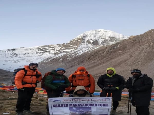
The map is not only a guide, but a spiritual guide to those who intend to make this pilgrimage. It is important to determine where you are in relation to Lake Manasarovar, Mount Kailash and the surrounding Himalayan landscape, so that your steps can have more significance. When you are aware of the distance, the altitude increases, and the road to go on, you travel with purpose and respect.
In case you are serious about this trip, you could use an operator that is well established, like Dream Tibet Travel & Tours Pvt Ltd, to which logistics, permits, and route planning are outsourced.