Preparing to take on the Kailash Mansarovar Yatra sounds thrilling, but it's also a little daunting. After all, where do you even start? This is exactly why the Kailash Mansarovar Yatra Route Map is one of the most critical aspects of preparing for this sacred journey.
Thousands of travelers from around the world - tourists and pilgrims - make their way to Lake Mansarovar and Mount Kailash in western Tibet every year.
This isn't merely a tour, especially not for the devout Hindus, Buddhists, Jains and Bonpo followers - it is a spiritual endeavor of a lifetime that is intertwined with religion, nature, and self-discovery.
But getting to Mount Kailash isn't as easy as getting a plane ticket to a new place and taking a car. You have many ways to go, multiple border crossings, many permits to get, high-altitude roads, and many stoppages in between. If you do not have any idea of the route beforehand, most tourists don't know what they need to do.
This complete guide of Kailash Mansarovar Yatra Route Map is to simplify your trip planning. Whether you are visiting from Nepal, India or somewhere else, this article will describe every single significant stoppage in the simplest language.
Inside this guide, you'll discover:
Kailash Mansarovar route guide step by step
The most common route starts from Kathmandu via Kerung.
Other routes from India: Liupulekh Pass, Nathu La, and more.
Day-to-day itinerary with must-visit destinations.
Distance and height guide to each major destination.
Kailash Kora trek in its entirety.
At the end of this guide, you'll have a full map of the entire pilgrimage, be fully aware of the day-to-day itinerary, and be ready to plan the journey of a lifetime to this other-worldly destination! Let's start by exploring the entire Kailash Mansarovar Yatra Route Map and tracing the journey from Nepal to Kailash.
Complete Kailash Route Maps Explained
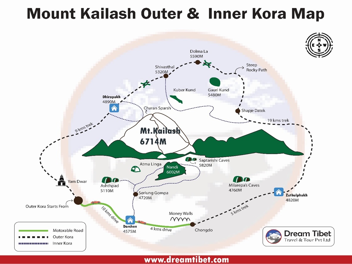
Mount Kailash Tour and Mount Kailash Kora Route Map
Route
Distance
Duration
Difficulty
Suitable For
Standard Overland Route (Kathmandu – Kerung – Saga – Lake Manasarovar – Darchen)
Kailash Mansarovar Yatra Route Map can give pilgrims all of their journey information right from before their travel begins. The area is very remote, and there is no direct route to reach Kailash by road or flight. Mount Kailash is situated in western Tibet, so you need to travel by Nepal or India to cross the border of China to enter Tibet; then the further journey is done by road until the last point to cover the trek.
Currently, the Kathmandu-Kerung-Saga-Lake Mansarovar-Darchen route is one of the most used routes among international travelers. It has improved road connectivity, decent places to stay at many places, and enough time for acclimation. Most of the travel agencies also consider this route as it has a smoother travel flow.
Complete Route Overview
A typical Kailash Mansarovar Yatra follows this route:
Kathmandu → Syabrubesi → Kerung Border → Kerung → Saga → Paryang → Lake Mansarovar → Darchen → Yam Dwar → Dirapuk → Dolma La Pass → Gauri Kund → Zutulpuk → Darchen → Return via Saga and Kerung to Kathmandu
The journey spans a distance of approx. 1,500 to 1,700 kilometers, depending on the particular route and trekking agency. If you include the 3-day trek around the holy Kailash Kora, the trip can take between 10 - 14 days for most pilgrims.
You'll journey from the verdant hills of Nepal to the remote and sparsely populated Tibetan Plateau, which is a world away! You'll navigate mountain passes that are snow-capped even during summer, traverse roaring river valleys, pass emerald-green and impossibly blue lakes, cross high-altitude desert, and trek through vast grasslands, all to reach the mystical mountain of Kailash.
Major Stops Along the Kailash Mansarovar Route
Each stop along the way is significant, and knowing them can better equip you to undertake the journey.
Kathmandu - The Starting Point
Most pilgrims traveling from abroad begin their journey from Kathmandu. From here, they have their pre-departure briefing, do visa/permit formalities, and get to meet their guide to prepare for the altitude they will soon be experiencing.
Some even take time to visit holy temples like the Pashupatinath before they depart to Tibet, in order to obtain blessings for a smooth and safe journey.
Syabrubesi - Gateway to the Himalayas
Your journey to Syabrubesi from Kathmandu involves some of the most rewarding Himalayan roads with beautiful terraced rice paddies and villages to admire. The town itself is the furthest settlement on the Nepali side of the border with Tibet and your final overnight point before approaching higher terrain.
Your altitude on the day remains well within comfortable limits as you continue to gain a slight height to ease the ascent to higher reaches.
Kerung Border
The border of Nepal and Tibet is the Kerung pass, and now most of the world wide pilgrims enter the land of Tibet after clearing immigration in Nepal & Tibet, respectively. Further in, this road becomes smoother and wider, with the amazing beauty of the plateau.
Kerung Town
Kerung (approximately 2,700 m altitude) is another vital acclimatization stop during the journey. Pilgrims often spend a night in Kerung to let their bodies adjust with reduced oxygen before they move to much higher altitudes. This step is critical to minimize the likelihood of catching altitude sickness.
At an altitude of around 4,640 meters (15,223 ft), Saga is one of the largest towns along the trail and a welcome place to stay for the night. The facilities at Saga include hotels, restaurants, pharmacies, fueling stations, and small stores. By this stage, pilgrims will generally feel the altitude.
Saga
Saga is one of the last towns with facilities, so make sure to stock up on whatever you may need.
The road trip to Saga also brings many spectacular vistas as you cross huge river plains, traverse grasslands where herds of wild Tibetan antelopes and yaks roam, and pass beneath the shadows of majestic Himalayan mountains with their white peaks.
Paryang
Paryang is a quiet settlement that lies in the middle of the gigantic Tibetan Plateau.
Despite being a modest town, it serves as an indispensable stopover overnight before you arrive at the holy Lake Mansarovar. The terrain surrounding Paryang is extraordinary-as far as your eye goes, all you can see are wide plains stretching to meet the horizon, all under the vast expanse of an azure sky.
Lake Mansarovar
Lake Mansarovar, which lies on the west of Lake Rakas, on the same vast Tibetan plateau at an elevation of 4,590 meters, is the second most sacred site for pilgrims in Tibet after Mount Kailash.
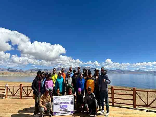
Many pilgrims consider reaching Lake Mansarovar to be the highest point of the whole pilgrimage, where they come to perform various prayers and meditation and enjoy the spectacular view of Mount Kailash in the distance. Some people also take some water from the lake back home as it is believed to carry blessings for their relatives and friends.
Darchen - Base Camp for Mount Kailash
The last town before you start your legendary Kailash Kora is Darchen. This tiny settlement is a pilgrim's and trekker's staging post.
It’s the place where pilgrims get their backpacks packed, arrange yaks and porters, and take their last few sips of tea before setting out on the 3-day Kora trek around Mount Kailash. It has become much more modern in recent years, but the pace of life is still slow, and life here is dictated by the awesome surroundings of the Himalayas.
Kailash Kora Route
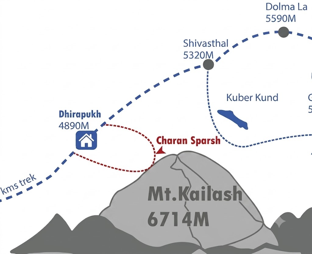
After leaving Darchen, the pilgrims arrive at Yam Dwar, traditionally the first stop for their sacred Kailash Kora.
The trek is undertaken via the route below:
Yam Dwar
Dirapuk Monastery
Dolma La Pass
Gauri Kund
Zutulpuk Monastery
Return to Darchen
The Kora stretches for around 52 kms and traditionally takes three days.
Crossing the highest stage, the 5,630 metre Dolma La Pass, the physically taxing hike offers what many feel is the most spiritual experience of the trip - representing new beginnings, purification and rebirth.
Return Journey
After finishing the Kailash Kora, the pilgrims make their way back to Darchen, and from there, the same route back through Saga, Kerung, and finally to Kathmandu.
While you'll see the same scenery, pilgrims say they see it differently as well, as if having undertaken this amazing journey somehow changes their perspective in the most positive of ways.
Why Understanding the Route Map Is Important
Knowing the Kailash Mansarovar Yatra Route Map before you travel will tell you exactly what to expect on a day-by-day basis. You will be able to assess how far you will be traveling each day, where you will be stopping to stay overnight, how much your altitude will be changing, and which sections of the Yatra will involve walking.
It allows you to prepare your body and your mind for the undertaking. Furthermore, it will help you pack the appropriate clothing, get acclimatized in good time, manage your stamina on the Yatra, and travel with added assurance.
In the next section, we will look at the various ways to undertake this Yatra, with specific reference to how you will go to Kailash Mansarovar – via the Nepal route, the various Indian Government authorized routes or taking a flight there.
Different Routes to Reach Kailash Mansarovar from Kathmandu
The most frequently asked question by pilgrims who plan a trip to Kailash Mansarovar: "What is the best route to reach there?" The route selection mostly depends upon your citizenship, your budget, the time you have at your disposal, your fitness levels, and your choice of travel style.
There are several routes to access Mt. Kailash and Mansarovar Lake, but there are primarily two well-known overland routes to the sacred destination from Nepal: the Kerung (Gyirong) Route and the Kodari-Zhangmu-Nyalam Route.
Both routes would bring you to the shores of Mansarovar Lake, and then you'd reach Darchen, which is where you start walking around the holy mountain, the famous Kora or Parikrama of Mount Kailash. The main differences lie in border crossing, rest points (acclimatization points), and the road taken across the vast plateau of Tibet.
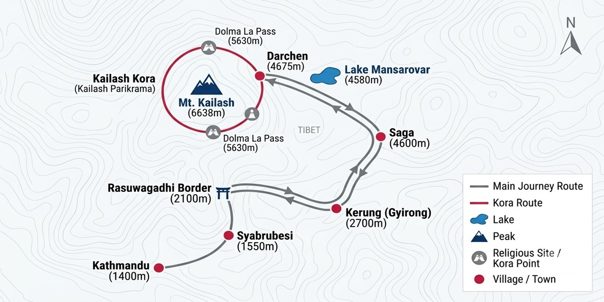
Kailash Mansarovar Tour Route Map 1: Kathmandu – Kerung – Saga – Lake Mansarovar – Darchen Route (Most Popular)
Mount kailash Tour Route Map Via Kerung
The Kathmandu via Kerung (Gyirong) route is the most popular for international travellers today. This route takes you up onto the Tibetan Plateau at a comfortable gradient, using the most comfortable road conditions and convenient accommodations. It is one of the better options for those visiting Tibet for the first time or the elderly pilgrims. This has become the route of choice for almost all organized tours to Mount Kailash and Lake Mansarovar, offering great scenery and comfortable accommodation.
Route Overview
Kathmandu → Syabrubesi → Rasuwagadhi Border → Kerung → Saga → Lake Mansarovar → Darchen → Kailash Kora → Return via the same route
The tour typically takes 14 to 16 days from the moment you enter Nepal until you depart back to Kathmandu, depending on the Kathmandu sightseeing. The itinerary usually has a day to acclimatize at Kerung (the border town), then move on to Saga and Lake Mansarovar to safely prepare yourself for the altitude.
Why This Route Is So Popular
This is currently the most popular overland travel route from Nepal.
This route involves a gradual ascent in altitude that allows travelers to acclimatize efficiently, hence minimizing the effects of altitude sickness.
The condition of the road throughout the Tibetan Plateau is good, and you don’t need any internal flights or helicopters, as the road will be used for the entire journey to Tibet and throughout the trip.
Kerung-Saga-Darchen has good guesthouses that will be used for your stay.
The overland route is ideal for families, seniors, and first-time pilgrims to Tibet. It is a preferable trip if you’re seeking a leisurely and beautiful experience during your pilgrimage.
The Kodari (Tatopani) Border was what most pilgrims used for many years to access Kailash before the Kerung border was opened for international travel. Most people will then travel through Zhangmu to Nyalam and then drive through the vast western plains of Tibet on what was once known as the “Friendship Highway.” This is still a viable option to get to Kailash as long as the international border is open. Many factors can influence whether the border is open or not, so pilgrims need to check the current situation when they are planning their Kailash yatra.
The entire itinerary takes around 10–12 days. This includes the acclimatization day(s) and the speed of pilgrims in completing the yatra. A single day’s acclimatization at Nyalam before moving to Saga, Paryang and then to Lake Mansarovar usually follows.
Why Pilgrims Choose This Route
A classic overland road trip to the holy Mount Kailash
Beautiful landscape of Zhangmu and Nyalam
The gradual acclimatization to high altitude in Nyalam
Traverse through Paryang to Lake Mansarovar
The ideal route to see beautiful landscapes of the Himalayas and Tibetan Plateau
Before you finalize any trekking plan, always check availability of border crossings as and when you choose to travel, whether crossing by Kerung or Kodari - Zhangmu depends on infrastructure, weather conditions and regulations of the government.
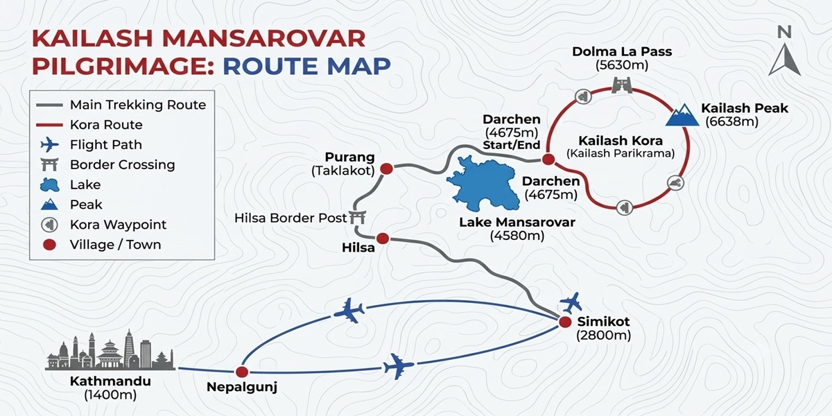
Mount kailash Tour By Helicopter Route Map Nepalgunj
For those who have less time, it is very hard to drive from Kathmandu all the way up to Tibet, especially if you are short of time. The quickest way to get to the Kailash Mansarovar is by taking domestic flights.
You will be flying to Nepalgunj from Kathmandu, then further on to Simikot, by helicopter to Hilsa and finally travelling on the road to Tibet.
Route Overview
Kathmandu → Nepalgunj → Simikot → Hilsa → Purang (Taklakot) → Lake Mansarovar → Darchen → Kailash Kora
This tour is normally for 9 to 11 days, so it is a good choice to opt for this route if you have time constraints.
Advantages
Saves several days of travel
Excellent choice for busy travelers
Less road travel inside Nepal
Spectacular Himalayan helicopter views
Things to Consider
More expensive than the overland route
Flights and helicopter schedules depend on weather
Delays can occur during the monsoon season
Faster altitude gain means proper acclimatization is even more important
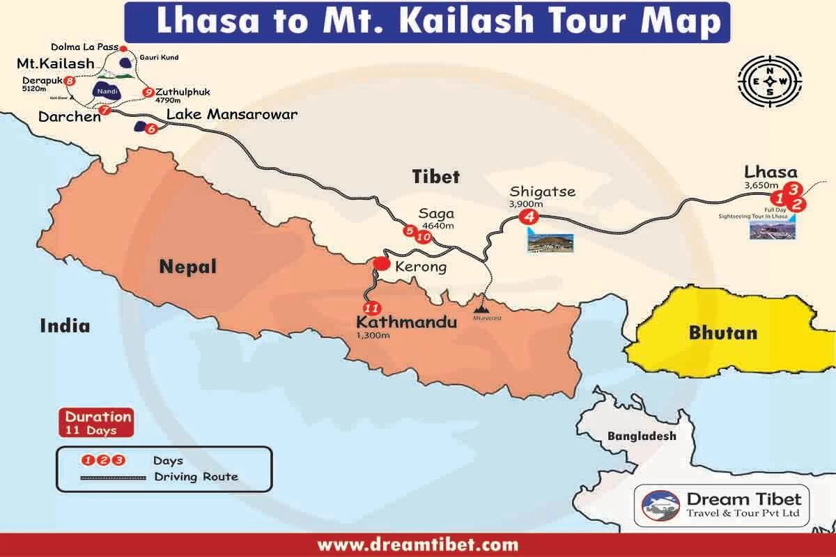
Kailash Mansarovar Tour Route Map 4: Lhasa – Shigatse – Saga – Lake Mansarovar – Mount Kailash Route (Best for Culture & Acclimatization)
Mount kailash Tour Via Lhasa Route Map
This is probably one of the most scenic and culturally rich options for traveling to Mount Kailash. Similar to the other options, you will start your trip from Lhasa, the capital city of Tibet.
Along the way, you will have opportunities to explore some of the most important monasteries of Tibet for a few days, which also allows you time to acclimatize yourself at the high altitudes. So if you are interested in having a spiritual pilgrimage along with a cultural tour of Tibet, then this is an amazing choice for you.
Route Overview
Lhasa → Shigatse → Saga → Lake Mansarovar → Darchen → Kailash Kora → Saga → Kyirung Border → Kathmandu
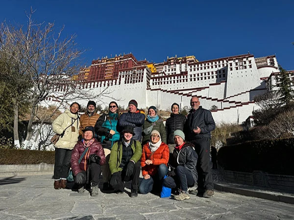
This normally takes 11 Days (2 full days of Acclimatization & sightseeing in Lhasa, then drive across the Tibetan Plateau). Along the route, visit World famous Landmark Potala Palace, Jokhang Temple, Barkhor Street, Drepung Monastery, Sera Monastery & proceed towards western Tibet for many Pilgrimage travelers for Adjustment on higher altitude.
Why Pilgrims Choose This Route
The perfect combination of a Tibet sightseeing tour with a Kailash pilgrimage tour.
2 days for acclimatization to avoid altitude problems while on your way to Lhasa.
Also, visit Potala Palace & other religious places, including Jokhang Temple & Barkhor Street in Lhasa. Plus, Drepung & Sera monasteries visit.
Then, scenic drive through Shigatse, Saga and Tibetan Plateau. From there, visit the sacred Lake Mansarovar before you start your Kailash Kora tour.
Best suited to those with extra time looking for an in-depth experience of Tibet.
Additionally, road conditions are excellent for much of your journey. You'll return to Kathmandu from the Kyirung border.
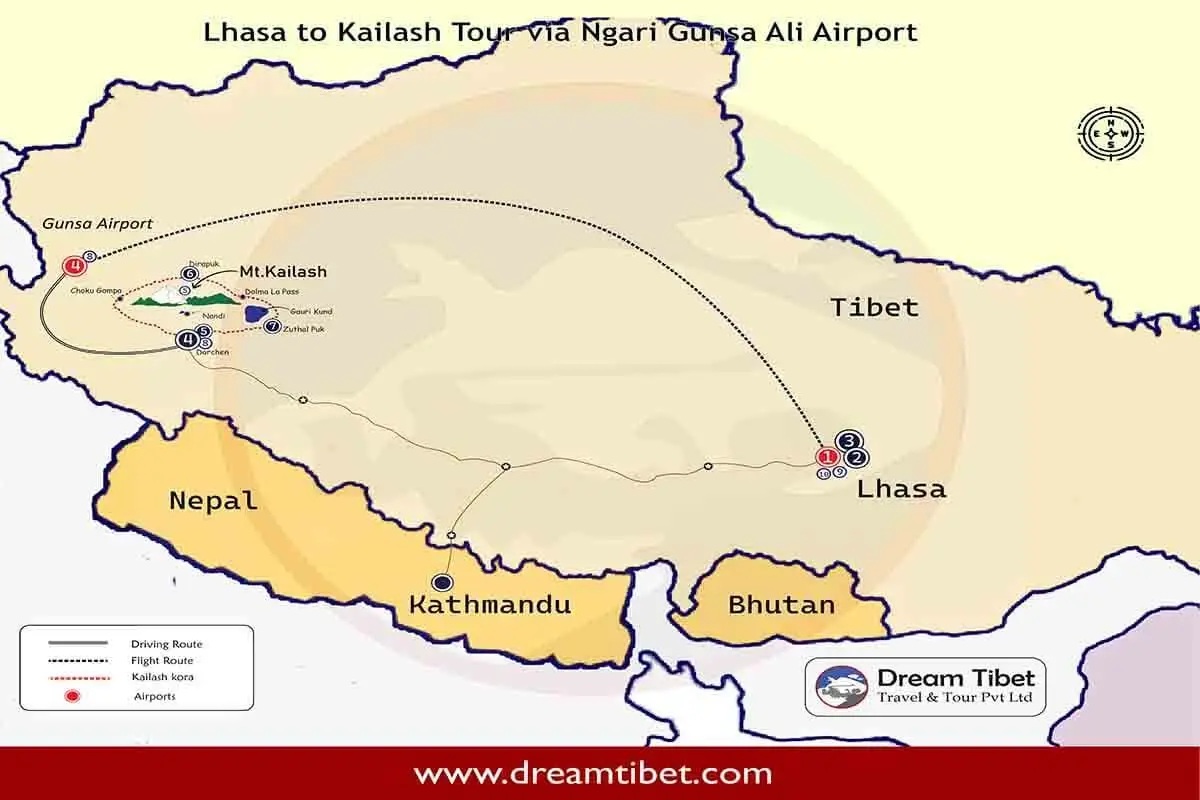
Kailash Mansarovar Tour Route Map 5: Lhasa – Ngari Gunsa Airport – Mount Kailash Route (Fastest Route from Lhasa)
Kailash yatra Via Ngari Gunsa Airport Route Map
If you are starting your trip in Tibet, traveling from Lhasa to Mount Kailash by taking a few days' drive through Western Tibet isn't really ideal. Instead, you can make this journey faster by flying directly into the nearby Ngari Gunsa (Ali) Airport in just 30 minutes.
You'll still need to spend some hours on roads going towards the small town of Darchen, which serves as the gateway to the holy mountain. But spending less than three days instead of over seven means that you'll have more time to explore all the wonders of Lhasa's famed culture without sacrificing too much in terms of your total travel duration.
Generally speaking, this is a 10-day trip. The pilgrim will spend two days sightseeing in Lhasa and then take an early morning flight from there to Ngari. After doing Kailash Parikrama for three days, the pilgrim returns to Ngari Airport and flies back to Lhasa to depart.
Why Pilgrims Choose This Route
The fastest flight route from Lhasa to Kailash.
Minimize your travel time on the road.
You can have a tour to see in Lhasa, then depart for Kailash.
Direct flight access to Ngari Gunsa Airport.
Save more time to do meditation, do prayers, and trek around Lake Mansarovar.
Suitable for you if you don't have many days for your trip. Mix the air and overland holy pilgrimage.
Perhaps one of the best things you can do in the run-up to the Yatra is to grasp just how long each stage will be. Your Kailash Mansarovar route map won’t just cover the distance you’ll travel but also detail how your altitude shifts along the path. In Tibet, although road conditions tend to be better than average, you are in for some particularly long hours on the road as well as a significant increase in your altitude.
Therefore, knowing the distance involved, driving time, and altitude for each halt is crucial – it helps you conserve your energy, prepare for acclimation, and gauge the demands for each day.
Some of the newer route notes do reiterate that the most difficult part of the Yatra isn’t the distance, but the altitude.
Kailash Mansarovar Route Distance Chart (Kathmandu via Kerung)
Route Segment
Approx. Distance
Travel Time
Altitude
Kathmandu → Syabrubesi
130–145 km
7–8 hours
1,550 m
Syabrubesi → Rasuwagadhi Border
15–20 km
30–45 minutes
1,800 m
Border → Kerung
25–30 km
1 - 2 hours
2,700–2,800 m
Kerung → Saga
260 - 300 km
6 - 8 hours
4,640 m
Saga → Paryang
250 - 260 km
5 - 6 hours
4,500–4,600 m
Paryang → Lake Mansarovar
260 - 280 km
5 - 6 hours
4,590 m
Lake Mansarovar → Darchen
30 - 40 km
About 1 hour
4,670 m
Darchen → Yam Dwar
6 - 8 km
20 - 30 minutes
4,700 m
Yam Dwar → Dirapuk (Trek)
18 - 20 km
6 - 8 hours
5,000 m
Dirapuk → Dolma La Pass
8 - 10 km
4 - 5 hours
5,630–5,636 m
Dolma La Pass → Zutulpuk
12 -14 km
5 - 7 hours
4,790 m
Zutulpuk → Darchen
10 -12 km (trek) + short drive
3 - 4 hours
4,670 m
Total Distance of the Kailash Mansarovar Yatra
If you choose the Kathmandu to Kerung overland route, you'll travel approximately:
Road Journey: 1,500–1,700 km (round trip)
Kailash Kora Trek: About 52 km over three days
Total Duration: Usually 13–16 days, depending on the itinerary
Even though the road mileage is long, it’s spread into smaller, manageable portions each day. Pilgrims are able to take breaks, adapt to the climate, and absorb the stunning panoramas of the Tibetan Plateau.
Which Day Has the Longest Drive?
It’s not just the trek that is difficult for Yatra pilgrims; some driving days can also be gruelling.
The longest road journeys are usually:
Kerung to Saga
Saga to Paryang
Paryang to Lake Mansarovar
These roads lead across wide open plains, with few towns in sight. You will pass over snow-capped mountains, highland pastures, glacial rivers and traditional Tibetan nomad camps.
Even though there are long stretches, high-grade roads in Tibet make driving much less rugged than most first-timers imagine.
Which Day Is the Most Difficult?
Today’s pilgrimage will culminate with Day 2 of the Kailash Kora, as you ascend to over 5,630 m above sea level over the challenging Dolma La Pass.
This section includes:
A steep uphill climb to the highest point of the pilgrimage
Thin air with significantly lower oxygen levels
Rocky and uneven mountain trails
A long descent toward the sacred Gauri Kund
Despite being rewarding, it is not a day that any of you can approach casually; crossing the Pass is the high point of the journey in more than one way for those of us on this global pilgrimage.
Why This Distance Chart Matters
If you take the time to study the Kailash Mansarovar route map and distance chart, you can easily prepare for your pilgrimage trip more wisely. Along with the distance covered, you will have a clear idea of:
What is the total distance to cover daily
The place you’d spend each night, the altitude gain during the entire journey
The days you will have to push yourselves harder
the time when you’d need rest and acclimatisation.
Once you know this, you can easily get yourselves both physically and mentally ready for a pilgrimage tour of a lifetime to the most popular destination on earth. Next section – Kailash Mansarovar Route altitude chart will provide information regarding the change in altitude while covering the Kailash Mansarovar tour, its symptoms and some tips and measures to acclimatise.
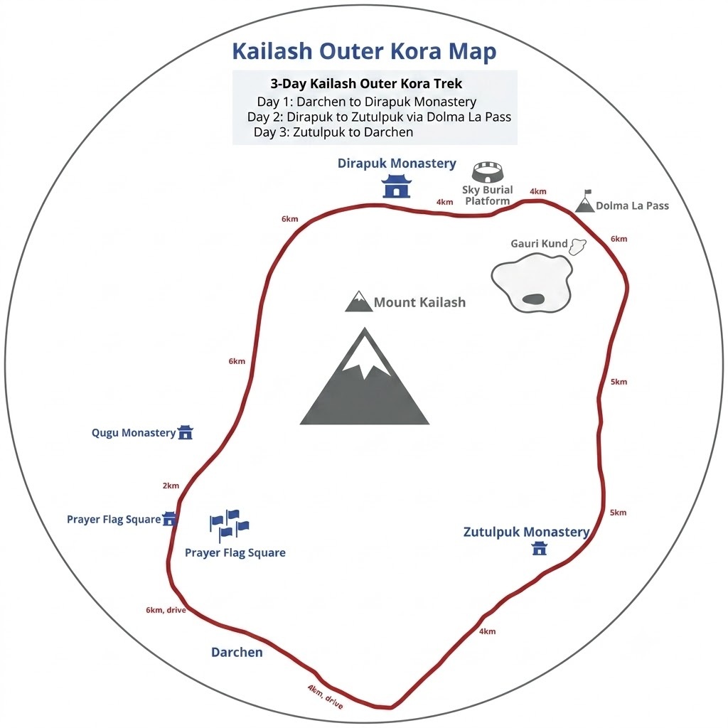
Outer Kailash Kora Route Map: The Ultimate 3-Day Trekking Guide
The Outer Kailash Kora (also known as the Outer Parikrama or circumnavigation of Mount Kailash) is one of the holiest pilgrimages on Earth. Every year, numerous pilgrims from Hinduism, Buddhism, Jainism and Bon descend upon the west of Tibet to circumambulate this holy mountain.
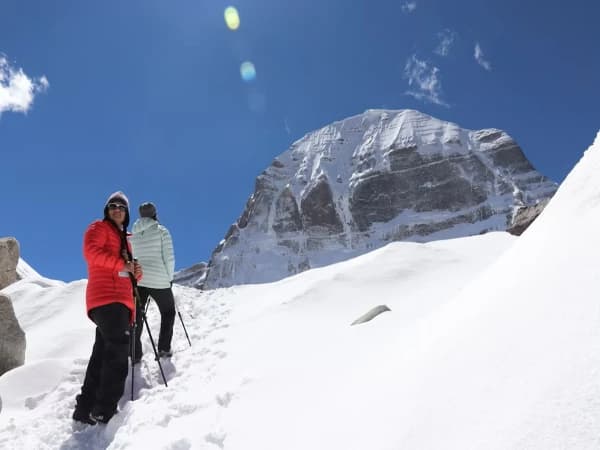
The 52 km-long (33-mile) trek is one of the world's best journeys; in this case, you walk around Mount Kailash (as opposed to the taboo and prohibited trek to summit Mt Kailash, which has a spiritual importance to it).
Hindu devotees believe that walking around Kora will purify the sins. For the Tibetan Buddhists, the kora brings merits for one to achieve enlightenment. Buddhists, Jains, and Bon believers also hold this path in extreme reverence.
If you are travelling to undertake this, you might need to understand the Outer Kailash Kora route map. The kora route tells you about your itinerary, where you will sleep, the total elevation increase every day and the holy sites you will encounter during the kora.
Outer Kailash Kora Route Map
Mount Kailash Outer Kora Route Map
The complete Outer Kora follows a well-established route around Mount Kailash.
North Face of Kailash
▲
│
Dirapuk Monastery
│
│
Dolma La Pass
│
Gauri Kund
│
Zutulpuk Monastery
│
│
Yam Dwar - - - - - - - - - - - - - - Darchen
Complete Trek Route
Darchen → Yam Dwar → Lha Chu Valley → Dirapuk Monastery → Dolma La Pass → Gauri Kund → Zutulpuk Monastery → Darchen
Total Distance: Approximately 52 km
Duration: 3 Days
Maximum Elevation: 5,630 meters
Starting Point: Darchen
Ending Point: Darchen
Difficulty: Moderate to Challenging
The path traverses around the mountain clockwise and follows the general route favoured by most Hindu and Buddhist pilgrims, while followers of Bon typically walk counter-clockwise.
Walking Route Explained
The pilgrimage is approx. 52 km long in distance but it should never be underestimated.
The challenge comes from:
High altitude
Thin oxygen
Rocky terrain
Long walking hours
Rapid weather changes
Fortunately, the route is divided into three manageable trekking days.
Day 1 Route: Darchen to Dirapuk
Distance: Approximately 20 km
Walking Time: 6–8 hours
Elevation
Start: Darchen (4,675 m)
End: Dirapuk (5,080 m)
The first day is the easiest leg of the entire pilgrimage. After a short drive from Darchen, pilgrims reach Yam Dwar, the start of the sacred journey. Passing through Yam Dwar signifies letting go of the material world and setting off for spiritual transcendence.
From here, the trail continues to the valley beside the pretty Lha Chu River, bordered by the snowy mountains. It is a gentle walk which allows easy acclimatisation.
Along the way you'll encounter:
Tibetan prayer flags
Yak caravans
Nomad camps
Small bridges
Mani stone walls
Crystal-clear streams
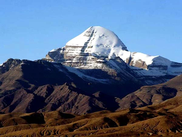
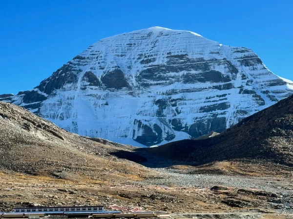
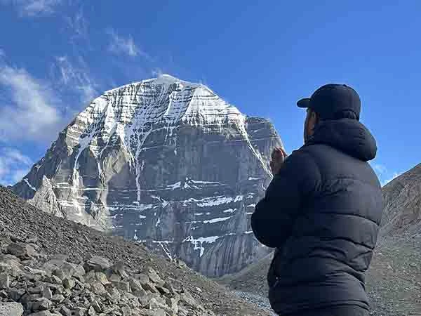
Near the end of the afternoon, the impressive North Face of Kailash reveals itself. Pilgrims call this the most moving moment of the first day.
Best Viewpoint: North Face of Mount Kailash
For anyone who wants to know from where the best images of Mount Kailash can be shot, the answer is Dirapuk.
From here you can clearly see:
the nearly vertical north face,
natural snow patterns,
dramatic rock formations,
and the mountain rising above the valley.
Many photographers agree that Dirapuk, at sunrise, offers the most outstanding perspective of Kailash, as the morning light reaches the peak, but the valley itself is still in shadow.
Dirapuk Monastery
Situated under the north face of Mount Kailash, this is a key pilgrimage stopping point on the Outer Kora.
Pilgrims often visit the monastery to:
meditate,
light butter lamps,
offer prayers,
and rest before the challenging second day.
Affordable dorm-style guesthouses located nearby offer simple meals, tea and accommodation, providing pilgrims with lodging in their dormitory facilities for the duration of the pilgrimage season, though by most international standards, they are very basic and no more comfortable than basic mountain accommodation.
Day 2 Route: Dirapuk to Dolma La Pass to Zutulpuk
Distance: Approximately 22 km
Walking Time: 8–12 hours
Maximum Elevation: Dolma La Pass [5,630 meters]
Without a doubt, this is the most difficult day of the whole Kailash Yatra. The walk to Dolma La normally starts just before the sun rises. The walk to Dolma La is an incline most of the time, but the last ascent is steep, stony and very demanding in such a low oxygen atmosphere.
Even fit people walk slowly in such a rarefied atmosphere; they do not hurry so much; the important point is that they have pace in walking; they move slowly and steadily.
Dolma La Pass
Dolma La is the summit and one of the holiest places on the Outer Kora of Kailash. In Tibetan Buddhism, it is called Dolma (Tara); here in Dolma La Pass, it is believed that the person is transformed spiritually.
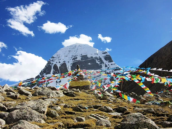
The mountain top is filled with prayer flags, a hundred thousand in brilliant colours against the Himalayan sky. Here in Dolma La pass, people spend some time praying, and after that, they begin to descend.
The weather here can change at any time, and snow can fall, and wind may blow strongly even during peak season.
Gauri Kund
Leaving Dolma La behind, you traverse the terrain downwards toward the verdant Gauri Kund. Hindu texts claim that Goddess Parvati meditated and took a dip in these turquoise waters, far below the trek.
Despite the challenging descent from the trek, Gauri Kund is an auspicious site that can be difficult to access in many situations. But the sparkling waters can be a brilliant hue in clear sunshine against the rocks and snowfields.
Zutulpuk Monastery
The hike concludes for the day at the peaceful Zutulpuk Monastery, which is linked to the famous Tibetan yogi Milarepa. Pilgrims will stay overnight in basic guest houses close to the monastery before concluding their Kora the next morning.
Accommodation typically includes:
shared rooms,
basic toilets,
simple Tibetan meals,
hot tea,
limited electricity.
Please note that luxury services are not to be expected given the secluded environment.
Day 3 Route: Zutulpuk to Darchen
Distance: Approximately 10 km
Walking Time: 3 - 4 hours
The last day of the trip is so much easier. The trekking route passes through a broad valley by the Zhong Chu River before we start to go down to the road for vehicle waiting. It’s a great time when pilgrims finish the last few miles; on one hand, they are happy about completing the sacred circuit of Kora.
On the other hand, they are grateful for this whole journey. On returning to Darchen, most people will hold a celebration.
Outer Kora Elevation Profile
Location
Elevation
Darchen
4,675 m
Yam Dwar
4,730 m
Dirapuk
5,080 m
Dolma La Pass
5,630 m
Gauri Kund
~5,600 m (below the pass)
Zutulpuk
4,790 m
Darchen
4,675 m
The profile shows a gradual climb on Day 1, a steep ascent and descent on Day 2, and a gentle finish on Day 3.
Outer Kora Distance Chart
Trek Section
Distance
Time
Darchen → Yam Dwar
7 km (drive)
20–30 min
Yam Dwar → Dirapuk
20 km
6–8 hrs
Dirapuk → Dolma La
8 km
4–5 hrs
Dolma La → Zutulpuk
14 km
4–7 hrs
Zutulpuk → Darchen
10–12 km
3–4 hrs
Zutulpuk
4,790 m
Darchen
4,675 m
Total trekking distance is approximately 52 km, though minor variations occur depending on the trail and road access.
Rivers Along the Outer Kora
Accompanying the pilgrims for the route are the following rivers:
The Lha Chu River, which travels beside the trail from Yam Dwar up to Dirapuk.
The Zhong Chu river which shadows the majority of the final days journey from Zutulpuk to Darchen.
These glacial rivers are integral to the spectacular scenery as well as historically used to orient pilgrims throughout the valley.
Monasteries Along the Route
The Outer Kora passes several important monasteries that have supported pilgrims for centuries.
Monastery
Significance
Dirapuk Monastery
Best views of the north face of Mount Kailash; overnight stop on Day 1.
Zutulpuk Monastery
Linked to the revered yogi Milarepa; overnight stop on Day 2.
These monasteries continue to be living places of prayer and some of the most spiritually important stops on the pilgrimage.
Best Viewpoints on the Outer Kora
If you want to capture the most memorable views of Mount Kailash, don't miss these locations:
Yam Dwar – the ceremonial gateway with your first distant views.
Dirapuk – the iconic north face, especially at sunrise.
Dolma La Pass – panoramic mountain vistas and colorful prayer flags.
Gauri Kund Viewpoint – striking views of the sacred turquoise lake.
Valley beyond Zutulpuk – peaceful river landscapes marking the final stage of the trek.
As with each side of the mountain, it looks distinctive, making the Outer Kailash Kora not solely a spiritual journey but also one of the best panoramic high-altitude trekking routes within the Himalayas.
The Outer Kailash Kora Route Map transcends that of a typical trekking route; it entails crossing sacred valleys, historic gompas, and glaciers. It passes that have motivated the devoted throughout the centuries.
If the goal of the journey is spiritual satisfaction, cultural revelation or testing one’s own limitations, an acquaintance with each phase of the path provides assurance, reverence and the required preparedness for such a momentous undertaking.
Kailash Inner Kora Route Map
Mount Kailash Inner Kora Route Map
The most challenging and inaccessible inner route that pilgrims undertaking this sacred journey can undertake is the Kailash Inner Kora (or Inner Parikrama). Thousands of devotees undertake the Kailash Outer Kora (around Mount Kailash) every year.
However, few ever manage the inner circumambulation. This path delves into the very core of the inner valleys around Kailash and goes into areas inaccessible on the conventional route.
As opposed to the Outer Kora, which goes along the path and around Kailash, this path closely circles the face of Kailash (especially the South Face), passing monasteries, meditation caves, stupas and even Nandi Parvat.
Much of the terrain will be over 5000 metres, at some points touching 5860 metres, and infrastructure will be almost non-existent. For most followers, this is more than a mere walk; this is believed to be the ultimate inner tour of the holy mount.
What Is the Kailash Inner Kora?
Inner Kora is another sacred circuit for pilgrims; this circuit doesn't include the whole circumambulation of Mount Kailash but circulates the southern side of Mount Kailash. It is like the Outer Kora; you can start and finish in Darchen.
However, instead of moving around the mountain on your way to Dolma La Pass, you'll move inside the inner valley and hike toward Serlung Monastery, Ashtapad, the South Face of Kailash, 13 Golden Chortens, Saptarishi Cave, Nandi Parvat, Gyangdrak Monastery and then return to Darchen.
Depending upon the trek plan, places like Charan Sparsh, Atmalingam, or Kuber Kund might also be visited.
In comparison to the Outer Kora, Inner Kora has shorter trekking distances but a considerably tougher trail due to:
Steeper ascents and descents
Rocky alpine terrain
Snow and ice in some seasons
Route-finding challenges
Limited infrastructure
Sustained high altitude
Why Do Tibetans Say You Should Complete 13 Outer Koras First?
One of the best-known rituals for Mount Kailash is the idea that a pilgrim must complete 13 Outer Koras before taking the Inner Kora. In long-established Tibetan Buddhist practice, performing 13 Outer Koras helps purify the pilgrim's body and spirit, as the Outer Kora refers to circumambulation around the sacred mountain, which allows the pilgrims to pass into Mount Kailash's inner sanctum.
In short, they've proved to themselves and the world how devoted they are! This is the most common way, but this tradition has been altered in recent years as experienced trekkers may do the Inner Kora having done as few as one Outer Kora, but only under these conditions:
local conditions allow access,
tour operators include the route in their itinerary,
guides consider the trek safe,
and the pilgrim is physically capable of completing it.
Whether this will be an option for you depends on weather, trail conditions, governmental regulations, and trekking agencies' policies.
Kailash Inner Kora Route Map
A commonly followed Inner Kora sequence is shown below.
DARCHEN
│
│
Serlung Monastery
│
│
Ashtapad
│
│
South Face of Mount Kailash
│
│
13 Golden Chortens
│
│
Saptarishi Cave
│
│
Nandi Parvat
│
│
Gyangdrak Monastery
│
│
DARCHEN
This order represents the most reported landmarks of present-day Inner Kora trips. The path, however, can change according to the weather, the state of the snow, legal restrictions and the trekking company that operates the trip.
In the longer Inner Kora trek package, Charan Sparsh, Atmalingam, Nandi La Pass, and Khandosanglam La Pass may also be added.
Detailed Inner Kora Route Explained
1. Darchen (4,675 m)
The start of each Inner Kora trek is from Darchen, the small pilgrim village located at the foot of Mount Kailash, where pilgrims stop for a break, make preparations and get themselves accustomed to the remote areas far away.
2. Serlung Monastery (Approx. 5,020 m)
The first attraction is Serlung Monastery. Being located on the south side of the Kailash Mountain, Serlung Monastery offers a great view of Kailash from the south face. It is visited by very few, which means it offers a very secluded and spiritual feel.
3. Ashtapad
The trail from the Serlung Monastery eventually proceeds towards Ashtapad, one of the most revered locations in the Jain faith, where Lord Rishabhadeva (Adinath) obtained his 'Moksha'. In Hinduism, this is seen as a prominent pilgrimage site owing to its vicinity to Kailash Mountain.
4. South Face of Mount Kailash
While Outer Kora is famous for its breathtaking views of the North Face, the Inner Kora takes you incredibly near to the South Face of Mount Kailash. This majestic rock wall and face of snow that most trekkers hardly get to see is the high point of Inner Parikrama. Most pilgrims meditate or pray at this spot.
5. 13 Golden Chortens (Approx. 5,860 m)
13 Golden Chortens (5,860 m) is another sacred spot in the Inner Kora are the 13 Golden Chortens or the Buddhist stupas. These are lonely religious stupas at a height of close to 5,860 metres, making it crucial to be properly acclimatised.
6. Saptarishi Cave
Nearby lies the well-known Saptarishi Cave, which is attributed in pilgrimage lore to the Seven Great Sages (Saptarishis). It may be very plain-looking, but it is considered one of the holiest spots within Inner Kora and often is the point where pilgrims sit for a few minutes in meditation.
7. Nandi Parvat
The route goes along Nandi Parvat, the holy mountain of Nandi, the divine bull who is the favourite disciple and consort of lord Shiva. This stretch of Inner Parikrama is called the Nandi Kora, and is perhaps the most wild and barren segment.
Most trekkers may be able to notice very little trace of human habitation here, with the path presenting steep ascents and treacherous rock surfaces.
8. Gyangdrak Monastery
Finally, there is the great monastery of Gyangdrak, which is one of the most historic in the area. On the way back down towards Darchen, the Inner Kora is completed.
Kailash Inner Kora Distance, Altitude & Difficulty Chart
Route Section
Approx. Distance
Highest Altitude
Walking Time
Difficulty
Darchen → Serlung Monastery
8–10 km
5,020 m
3–4 hrs
Moderate
Serlung → Ashtapad
4–5 km
5,150 m
2 hrs
Moderate
Ashtapad → South Face
4–5 km
5,600 m
2–3 hrs
Challenging
South Face → 13 Golden Chortens
3–4 km
5,860 m
2 hrs
Strenuous
13 Golden Chortens → Saptarishi Cave
1–2 km
5,860 m
30–60 min
Moderate
Saptarishi Cave → Nandi Parvat
4–5 km
5,805 m
2–3 hrs
Strenuous
Nandi Parvat → Gyangdrak Monastery
5–6 km
5,060 m
2–3 hrs
Challenging
Gyangdrak → Darchen
6–8 km
4,675 m
2–3 hrs
Moderate
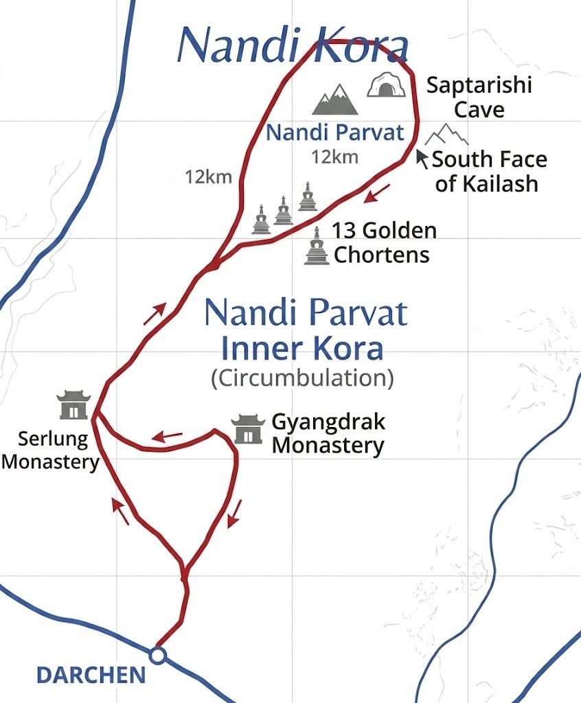
Nandi Kora Route Map: The Complete Guide to the Sacred Parikrama of Nandi Parvat
Nandi Kora Route Map
Of all the treks to Kailash, the Nandi Kora is the one of which we understand the least, and one of the most holy. Most pilgrims have heard of the Outer Kora and the Inner Kora, but very few know that there is a separate kora to the Nandi Kora. This walk circumnavigates Mount Kailash's neighbour: Nandi Parvat.
Normally, Nandi Kora is incorporated in the Outer Kora trek itinerary of present-day pilgrims. After reaching the valley of the inner regions, pilgrims circumambulate Mount Nandi, going by the Sacred Saptarishi Cave, 13 Golden Chortens and the South Face of Mount Kailash and make their way towards Darchen.
As a result of the difficult terrain and the height, this Kora is attempted by very acclimatised people only.
Since there are no properly marked paths or the provision of tea shops and accommodation (apart from basic campsites), a local guide is usually hired to undertake this trek, which passes through desolate and isolated valleys.
What is Nandi Parvat?
The holy Nandi Parvat is the peak located just south of Mount Kailash. Shiva, one of the most widely revered Hindu gods, is often portrayed with Nandi as a divine bull who faithfully acts as Shiva's guardian and vehicle.
For pilgrims, the mountain's silhouette has an uncanny similarity to the imposing figure of a sleeping bull – thus earning its designation as Nandi Parvat.
It also provides a natural wall to shield the peripheral valleys from the intensely sacred inner region surrounding Kailash.
Traveling the Nandi Kora path presents the rare and fortunate pilgrim with an eye-level perspective of the south side of Mount Kailash.
Why is Nandi Kora So Sacred?
The Nandi Kora is revered as entering into the heart of Kailash in its most sacred spiritual sense.
The Outer Kora circumscribes the Holy Mountain at its external edge. The Nandi Kora circumscribes Kailash through places most revered in multiple traditions as places of penance, deep meditation and spiritual awakening.
Pilgrims take this circuit to:
Pay homage to Lord Shiva and Nandi
Visit unique holy meditation spots almost unreached by tourists
Go as close to Mount Kailash without climbing the mountain in pilgrimage
Visit advanced stages of the Inner Kora
Moreover, Tibetan Buddhism tradition generally considers the Inner Kora (thus the Nandi Kora) to be restricted for those who have accomplished many Inner Koras of the holy mountain and show a level of spiritual development and readiness. It's a religious conviction rather than a formal travel restriction.
Nandi Kora Route Map
A commonly followed Nandi Kora route is shown below.
DARCHEN
│
│
Serlung Monastery
│
│
South Face of Kailash
│
│
13 Golden Chortens
│
│
Saptarishi Cave
│
│
Nandi Parvat
│
│
Gyangdrak Monastery
│
│
DARCHEN
This is a trek that is almost universally presented to visitors by veteran Kailash guides. Of course, the route may change with weather, snow cover, prevailing local policies, or even guide preference.
In addition, several tours include Ashtapad, Charan Sparsh, Atmalingam and also cross over the Khandosanglam La and Nandi La Pass (as Inner Kora).
Step-by-Step Nandi Kora Route
Stage 1: Darchen to Serlung Monastery
The journey starts from Darchen (4675 m). This is very different from the Outer Kora, as pilgrims do not go to Yam Dwar but south to Serlung Monastery via a very rough and unmarked mountain track.
Serlung Monastery is considered the spiritual entrance of the Inner Kora and provides a great view of Kailash from its south face.
Stage 2: Serlung Monastery to the South Face of Mount Kailash
The walk from Serlung leads to rockier and steeper ground as the pilgrims ascend beyond 5,500 m. They are afforded one of the best possible legal views of the South Face of Mount Kailash.
This is a hushed section of the mountain, and sees far fewer pilgrims than on the bustling Outer Kora.
Stage 3: South Face to the 13 Golden Chortens
As you gain altitude, you come to the spectacular 13 Golden Chortens, at about 5,860m. Here the going is getting rough with lots of scree and the odd bit of snow. Most people will stop for a prayer here and then proceed into the inner valley.
Stage 4: 13 Golden Chortens to Saptarishi Cave
Saptarishi Cave is a little way ahead from the chortens. Pilgrimage lore connects the cave to the Seven Great Sages (Saptarishis), and it's considered a site for meditation and spiritual introspection, one of the most serene stretches of the Nandi Kora.
Stage 5: Circumambulating Nandi Parvat
This is the heart of the Nandi Kora. In place of rounding Mount Kailash clockwise, trekkers skirt the deep valleys that ring the holy peak, passing by Nandi Parvat.
The path is narrow and stony, frequently a matter of discerning cairns and an experienced local guide who knows his way.
More extreme and expedition-type approaches are known to take high passes like Nandi La to emerge at the foothills near the Gyangdrak Monastery eventually; these are without doubt the most challenging sections of the whole Inner Kora.
Stage 6: Gyangdrak Monastery to Darchen
From Gyangdrak Monastery the path slopes down, eventually taking the pilgrimage back to Darchen. This route offers one of the most elusive and spiritually powerful journeys in the Kailash region.
Nandi Kora Distance, Altitude & Difficulty
Section
Approx. Distance
Highest Altitude
Time
Difficulty
Darchen → Serlung Monastery
8–10 km
5,020 m
3–4 hrs
Moderate
Serlung → South Face
5–6 km
5,600 m
2–3 hrs
Challenging
South Face → 13 Golden Chortens
3–4 km
5,860 m
2 hrs
Strenuous
13 Golden Chortens → Saptarishi Cave
1–2 km
5,860 m
30–60 min
Moderate
Saptarishi Cave → Nandi Parvat Circuit
8–10 km
5,800+ m
4–6 hrs
Very Strenuous
Nandi Parvat → Gyangdrak → Darchen
10–12 km
5,060 m
4–5 hrs
Challenging
Nandi Parvat → Gyangdrak Monastery
5–6 km
5,060 m
2–3 hrs
Challenging
Gyangdrak → Darchen
6–8 km
4,675 m
2–3 hrs
Moderate
Approximate Total Distance: 30–35 km (depending on the exact route)
Maximum Altitude: Around 5,860 meters
Who Can Do the Nandi Kora?
Nandi Kora is not suitable for a new high-altitude trekker, but is well suited for:
Pilgrims who have successfully finished the outer Kora
Experienced mountain trekkers
Pilgrims who are well acclimatized over 5000m
Pilgrims who are at ease trekking on rugged unmarked alpine trails
Pilgrims with proper permissions and traveling with the experienced Kailash guide.
Given that conditions with snow and weather can vary significantly in any particular year, the full Nandi Kora will not always be possible even for Inner Kora trekkers. Please check the conditions of the route before travel with your trekking partner.
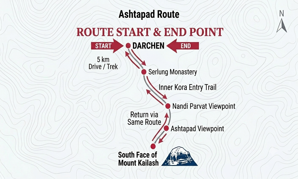
Ashtapad Route Map: Complete Route to the Sacred Jain Pilgrimage Site
Ashtapad Route Map
One of the most revered sites in the Jain pilgrimage tour is Ashtapad. As per the legends of Jainism, the very first Tirthankara of Jainism, Lord Rishabhadeva or Lord Adinath, reached Moksha (salvation) after meditating for numerous years in Ashtapad. This has made Ashtapad the origin of enlightenment in Jainism and one of the holiest places connected to Mount Kailash.
Today, Ashtapad is assumed to be present in the vicinity of the south face of Mount Kailash, and it is also located quite close to Serlung Monastery and Nandi Parvat.
It differs from the conventional Kora around the Outer Kailash Kora as Ashtapad falls in the difficult and secluded region of Inner Kailash Kora.
Ashtapad Route Map
The traditional approach to Ashtapad follows this route:
DARCHEN
│
5 km Drive / Trek
│
Serlung Monastery
│
Inner Kora Entry Trail
│
Nandi Parvat Viewpoint
│
Ashtapad Viewpoint
│
South Face of Mount Kailash
│
Return via Same Route
│
DARCHEN
While there isn’t any “circular trekking” for Ashtapad, unlike for the Outer Kora, pilgrims journey in from Darchen along the Inner Kora valley to visit the permitted area or viewpoint for Ashtapad, and then return by the same route back to Darchen.
Step-by-Step Route to Ashtapad
Stage 1: Darchen to Serlung Monastery
The Outer Kora pilgrimage starts from Darchen (4,675 m), heading roughly 5 km via transport or trekking, depending on road conditions and program logistics, to the monastery of Serlung (Selung). This is where the Inner Kora region can be entered from.
Stage 2: Serlung Monastery to the Inner Valley
After Serlung Monastery, pilgrims move off the known Outer Kora route and take a winding stone trail that ascends south-westwards gently along the south-west slopes of Mount Kailash. It gets more rocky with no teashops or guest houses.
This section offers magnificent views of:
Mount Kailash's South Face
Nandi Parvat
Glacial valleys
High-altitude meadows
Since it is very unmarked terrain, most groups are accompanied by local Tibetan guides.
Stage 3: Nandi Parvat Viewpoint
On the route to Ashtapad, the Nandi Parvat or Lord Shiva’s divine bull mount is seen. Beyond that, everything is Kailash. You look up at the enormous south face of Mount Kailash.
People sometimes pause at this point to do some meditation and prayer and then head on towards the actual Ashtapad site. It is also a major point on various Inner Kora routes and on some Nandi Kora routes.
Stage 4: Ashtapad Area
Pilgrims hike hours from Serlung into what is described traditionally as Ashtapad. Depending on the time of the season and the governing laws at present, the traveller can visit an official viewpoint in the vicinity of Ashtapad or get access closer to the pilgrimage site if specially allowed.
In the modern day, the popular pilgrimage to the place known historically as Ashtapad is now restricted to the darshan, with tours being more oriented towards the viewpoint due to restrictions.
Distance, Altitude and Trek Information
Route Section
Approx. Distance
Highest Altitude
Walking Time
Darchen → Serlung Monastery
5 km (drive or walk)
~4,900–5,020 m
20–30 min drive or 1.5–2 hrs on foot
Serlung → Nandi Parvat Area
5–6 km
~5,200 m
2–3 hrs
Nandi Parvat → Ashtapad Viewpoint
2–4 km
~5,200–5,300 m
1–2 hrs
Return via the same route
12–15 km
Descending
3–5 hrs
Approximate Total Distance: 18–22 km round trip, depending on the approved turnaround point and current access.
Can You Visit Ashtapad Today?
It's probably one of the biggest misconceptions about the Kailash trek. Historically, pilgrims used to have far more freedom to get closer to the Ashtapad traditional area. These days, access to the region is controlled by local authorities; permits are often required, and access depends on the season and policies dictated by the Indian and Tibetan governments.
Many years ago, it was impossible to reach the real Ashtapad, as tourists would only be able to reach viewing points close to the area. Because the regulations can change, it's a good idea to consult with your tour operator prior to travel for current access policies.
Even without direct darshan or glimpse, this pilgrimage journey from Serlung Monastery through Nandi Parvat to the south face of Mount Kailash would remain one of the most rewarding spiritual experiences in the Kailash region.
For the Jain community, even sighting the environs of the place of Lord Rishabhadeva's attainment is devotional.
Charan Sparsh Route Map: How to Reach the Feet of Mount Kailash
Charan Sparsh Route Map
For many Hindu devotees, Charan Sparsh is the most spiritually poignant moment during the Kailash Mansarovar Yatra.
While traversing the Outer Kailash Kora is an accomplishment of its own, Charan Sparsh allows devotees the experience of walking up to the foot of Mount Kailash’s North Face and laying a hand (literally a “foot”, or “Charan” as it’s known in Hindi) of Lord Shiva’s heavenly abode.
Unlike Outer Kora or Inner Kora, Charan Sparsh isn't a standalone pilgrimage. It is actually a day trek from Dirapuk Monastery, following which one either comes back to Dirapuk Monastery to complete the Outer Kora to Dolma La Pass or takes a shortcut in the Inner Kora route.
Since the trek is in the vicinity of Mount Kailash compared to Outer Kora, this place is most sacred for pilgrims.
What Does Charan Sparsh Mean?
The practice of “Charan Sparsh” in Sanskrit signifies “touching the feet”. In the Hindu religion, it’s common practice to touch the feet of our parents, guru(teacher), saint, or god as a gesture of showing our respect, submission, and devotion. In the holy Kailash Yatra trek, the pilgrims walk all the way to the rocks at the foothills of the North Face of the sacred Mt. Kailash.
Kailash is regarded as the “feet” of the abode of Lord Shiva.
Numerous pilgrims contemplate at the holy site, chant ‘Om Namah Shivaya,’ and go in for a bit of quiet introspection before they finally retreat.
Charan Sparsh Route Map
The route is simple but physically demanding because of the altitude.
DARCHEN
│
(Day 1 Trek)
│
Yam Dwar
│
Lha Chu Valley
│
Dirapuk Monastery
│
North Face Trail Junction
│
Boulder Field
│
CHARAN SPARSH POINT
(Base of Mount Kailash)
│
Return Same Way
│
Dirapuk Monastery
│
Continue Main Kailash Kora
Unlike the Outer Kora, Charan Sparsh follows an out-and-back route, meaning pilgrims return along the same trail after reaching the sacred point. There is no circular loop around the mountain.
Step-by-Step Charan Sparsh Route
Stage 1: Darchen to Dirapuk
The route is identical to the Outer Kora, starting at Darchen.
Pilgrims walk to Yam Dwar and trek approximately 20 km via the beautiful Lha Chu Valley to reach the monastery at Dirapuk, where most groups rest and adjust to the high altitude before attempting Charan Sparsh early in the morning of the following day.
Stage 2: Dirapuk to the North Face Trail
It’s just before sunrise as we pilgrims begin to hike away from Dirapuk – walking into the mountain range – up a narrow, winding path to the sheer North Face of Mount Kailash.
This is different from the spacious Outer Kora path we’ve been walking; this path starts to get narrow almost immediately and steeper very soon. The higher up you climb, the higher the mountain seems, and the imposing ice falls start taking up the view from here onwards.
Stage 3: Boulder Field
You hike through a large expanse of glacial rocks & boulders after about 3-4 km. This is the most challenging patch in terms of physicality.
Pilgrims carefully walk across jagged rocks, slowly ascending to the foot of Kailash. As you are already at 5,200 - 5,300m altitude, just a few meters takes you short of breath.
Stage 4: Charan Sparsh Point
Then the pilgrims finally reach the holy Charan Sparsh Point. Immense rock walls soar almost perpendicular to the valley in this holy place, which offers a spectacular, if extremely restricted access, vista to the mount of Kailash.
Many devotees:
Offer flowers or prayer scarves.
Chant sacred mantras.
Sit in silent meditation.
Touch the rocks near the mountain's base as an act of reverence (where conditions and local guidance permit).
After spending time in prayer, pilgrims return to Dirapuk along the same route.
Charan Sparsh Distance, Altitude and Difficulty
Route Section
Distance
Highest Altitude
Time
Difficulty
Dirapuk → North Face Junction
2 km
5,050 m
45–60 min
Moderate
Junction → Boulder Field
1.5 km
5,180 m
45 min
Challenging
Boulder Field → Charan Sparsh
1 km
5,250–5,300 m
45–60 min
Strenuous
Return to Dirapuk
3.5 km
Descending
2–3 hrs
Moderate
Total Distance: Approximately 7 km round trip
Walking Time: 4–6 hours
Maximum Altitude: Around 5,250–5,300 meters (varies slightly by GPS device and turnaround point).
Who Can Do the Charan Sparsh Trek?
The Charan Sparsh trek, while much shorter than the Inner or Outer Kora, is not a difficult trek due to its high altitude. This is the recommended hike for those who:
have arrived at Dirapuk with no issues of altitude.
Are comfortable and well-acclimatized over 5000m
Can walk on rough ground and rocky areas.
Listen to their Tibetan guide, local and custom.
Please note that access to the final Charan Sparsh location is often hindered by weather, snow conditions, ice flow, and local laws, and guides may turn the group around if they think it is unsafe to proceed all the way up.
Many believe the ultimate spiritual experience in this entire Kailash Mansarovar Yatra happens at the bottom of the North face of Mount Kailash, and the experience of being so close to one of the holiest mountains in the world is simply profound.
Saptarishi Cave Route Map: How to Reach the Sacred Cave of the Seven Sages
Saptarishi Cave, while less commonly mentioned than Outer Kailash Kora or Inner Kailash Kora’s other unique destinations, perhaps holds the most allure of all the unknown sites near Mount Kailash.
Not found like Mansarovar Lake or the yam Dwar near Kailash, this spiritual haven lies at the very core of the Inner Kora( Inner parikrama).
In Hindu belief, the cave relates to the Saptarishis: Atri, Bharadvaja, Gautama, Jamadagni, Kashyapa, Vishwamitra, Vashistha, who had come to meditate in the sacred Himalayas while worshipping Shiva.
In Tibetan Buddhist beliefs as well, this place is known as one of the holiest meditation places, near the 13 Golden Chortens below Mt Kailash in the southern direction.
Due to its location on the tricky Inner Kora, which may have conditions on permit availability and weather in the remote area, Saptarishi Cave is among the least frequented holy destinations in the region.
Saptarishi Cave Route Map
The commonly followed pilgrimage route is:
DARCHEN
│
Serlung Monastery
│
Ashtapad Area
│
South Face of Mount Kailash
│
13 Golden Chortens
│
SAPTARISHI CAVE
│
Nandi Parvat
│
Gyangdrak Monastery
│
DARCHEN
This is no designated path, and neither is it the route for the Outer Kora. The Saptarishi Cave can only be entered upon crossing the valley to the Inner Kora. Skilled Tibetan guides shepherd pilgrims across stone slopes in mountainsides devoid of marked pathways or built shelters.
Step-by-Step Route to Saptarishi Cave
Stage 1: Darchen to Serlung Monastery
Starting from Darchen (4,675m), we take Inner Kora to the southern direction for the most important monasteries located in the southern region of Mt. Kailash, which is the Serlung Monastery. It is a relatively easy hike, allowing us to adjust ourselves.
Stage 2: Serlung Monastery to Ashtapad
The trail gains altitude steadily from Serlung up the valley to the Inner Kora valley. Pilgrims pass spots traditionally identified as Ashtapad, which in Jainism is where Lord Rishabhadeva obtained his Moksha by tradition.
The path now becomes significantly rougher and more rocky than in the more gentle stretches on the Outer Kora.
Stage 3: Ashtapad to the South Face of Mount Kailash
Our route moves on towards the imposing South Face of Mount Kailash. This is one of the few accessible, safe points from where you can legally obtain stunning views of the sacred peak, and where several pilgrims take a moment of meditation and prayer.
The trail is far less frequented as it is part of the Inner Kora, so it has a wonderfully still, isolated atmosphere.
Stage 4: South Face to the 13 Golden Chortens
The trail climbs from the South Face towards the 13 Golden Chortens, at a height of about 5,860 meters. These are the highest reaches of the Inner Kora, and the air here becomes distinctly thinner.
Rock landscapes are replaced by the glacially hewn ones, and pilgrims traverse the distance at a sedate pace, stopping to catch their breath and rest as the thin air takes its toll.
Stage 5: 13 Golden Chortens to Saptarishi Cave
The last leg of the Saptarishi Cave is a quick but somewhat strenuous hike. The cave is not far from the chortens and tucked into the rocks below the cliffs on the slope near Nandi Parvat.
Traditional stories suggest that the Seven Great Sages meditated here intensely while seeking the blessings of Lord Shiva; some also say the cave represents the seven cosmic creative elements. Often, pilgrims use the tranquil solitude to meditate for a bit before proceeding with the Inner Kora around Nandi Parvat.
Saptarishi Cave Distance, Altitude & Trek Details
Route Section
Approx. Distance
Highest Altitude
Walking Time
Darchen → Serlung Monastery
8–10 km
5,020 m
3–4 hrs
Serlung → Ashtapad
5–6 km
5,200 m
2–3 hrs
Ashtapad → South Face
4–5 km
5,600 m
2 hrs
South Face → 13 Golden Chortens
3–4 km
5,860 m
2 hrs
13 Golden Chortens → Saptarishi Cave
1–2 km
5,860 m
30–60 min
Approximate Total Distance from Darchen: 22–27 km (depending on the expedition route)
Maximum Altitude: Around 5,860 meters
Difficulty Level: Very Strenuous
These distances vary slightly because Inner Kora expeditions may follow different lines based on snow, weather, and guide decisions.
Can Everyone Visit Saptarishi Cave?
No. Saptarishi Cave is not part of the standard Kailash Mansarovar Yatra.
To reach it, pilgrims must:
Join an approved Inner Kora expedition.
Be fully acclimatized above 5,000 meters.
Trek with an experienced local guide.
Travel when weather and local regulations allow access.
Some operators mention that parts of the Inner Kora, specifically Saptarishi Cave, can also be off-limits during certain times of the year due to security reasons or by governmental decisions. Always verify your travel status beforehand if undertaking such an advanced pilgrimage route.
To those who are able to get to the Saptarishi Cave, the location offers much more than merely a trek. High up in the secluded valleys of Mount Kailash, the place is among the most isolated spots of meditation in the Himalayas and continues to be a gem on the Kora Route Map.
Saptarishi Cave Route Map: How to Reach the Sacred Cave of the Seven Sages
In the list of remote pilgrimage destinations scattered in the vicinity of Mt. Kailash, the Saptarishi Cave perhaps stands as one of the most revered and secretive ones. Unlike many of the popular pilgrimage sites, such as Lake Mansarovar, Yam Dwar, or even the popular Outer Kora, Saptarishi Cave lies nested right at the sacred Outer Kora (Inner Kora / Inner Parikrama) and requires travelling in one of the most uninviting terrains.
The Saptarishi cave, linked with the Seven Great Sages (Saptarishis) of Hinduism who meditate in the Himalayas, devoted to Shiva, is considered holy also by Tibetan pilgrims. They are among the other thirteen Golden Chortens to be found at the southern face of Mt. Kailash in the vicinity of this area for meditation.
Because of being a little away from the normal trekking routes and access restricted to the difficult Inner Kora, and subject to permits and the mercy of nature and local rules, it is one of the least visited sacred places around Kailash.
Saptarishi Cave Route Map
The commonly followed pilgrimage route is:
DARCHEN
│
Serlung Monastery
│
Ashtapad Area
│
South Face of Mount Kailash
│
13 Golden Chortens
│
SAPTARISHI CAVE
│
Nandi Parvat
│
Gyangdrak Monastery
│
DARCHEN
This is not a marked tourist route, unlike the Kora Outer. Saptarishi Cave comes only once you make it to the Kora Inner valley, the Tibetan pilgrims are guided through mountain terrain which becomes increasingly rocky, and where there is virtually no infrastructure and few marks.
Step-by-Step Route to Saptarishi Cave
Stage 1: Darchen to Serlung Monastery
We start at Darchen (4,675 m), the starting point of all Mount Kailash pilgrimages. Inner Kora pilgrims walk south, not towards the Outer Kora to Yam Dwar, but to the Serlung Monastery, the major monastery situated in the southern part of Mount Kailash.
This part of the journey is easy and serves to get trekkers acclimatized to the altitude.
Stage 2: Serlung Monastery to Ashtapad
Leaving Serlung, the track climbs steadily into the inner Kora valley. Along the way, pilgrims walk between points traditionally designated as belonging to the Jainist site of Ashtapad.
It is said to have been the site where Rishabhadeva found his Moksha or Nirvana in Jain lore.
The track now gets progressively rougher with looser stones than the wider ones found on the Outer Kora.
Stage 3: Ashtapad to the South Face of Mount Kailash
Afterwards, we continue to the impressive south face of Mount Kailash. This is a privileged view on the holy mountain – one of the very few ones that you can legally reach – where many travelers are in the habit of staying for prayers.
The trail towards here is much less visited, and you have a serene sense of solitude.
Stage 4: South Face to the 13 Golden Chortens
The path reaches the 13 Golden Chortens at about 5860 meters from the South Face. That’s almost the summit of Inner Kora. You’ll feel a drastic decrease in oxygen, and rocks give way to glaciers.
Pilgrims slowly make progress up, stopping quite often due to the altitude.
Stage 5: 13 Golden Chortens to Saptarishi Cave
The walk to Saptarishi Cave is short, but not a breeze. It’s a short but a little difficult walk, located behind the chortens near the cliff faces of the slopes near Nandi Parvat.
The story goes that it’s where the Saptarishi or Seven Great Sages meditated seriously for days, hoping to obtain blessings from Lord Shiva; while some also believe the Saptarishi Cave represents the Seven Cosmic Energies of Creation.
Most pilgrims meditate here for some time before proceeding to take a clockwise path around the Sacred Mountain to Nandi Parvat – the Inner Kora.
Saptarishi Cave Distance, Altitude & Trek Details
Route Section
Approx. Distance
Highest Altitude
Walking Time
Darchen → Serlung Monastery
8–10 km
5,020 m
3–4 hrs
Serlung → Ashtapad
5–6 km
5,200 m
2–3 hrs
Ashtapad → South Face
4–5 km
5,600 m
2 hrs
South Face → 13 Golden Chortens
3–4 km
5,860 m
2 hrs
13 Golden Chortens → Saptarishi Cave
1–2 km
5,860 m
30–60 min
Approximate Total Distance from Darchen: 22–27 km (depending on the expedition route)
Maximum Altitude: Around 5,860 meters
Difficulty Level: Very Strenuous
These distances vary slightly because Inner Kora expeditions may follow different lines based on snow, weather, and guide decisions.
Can Everyone Visit Saptarishi Cave?
No. Saptarishi Cave is not part of the standard Kailash Mansarovar Yatra.
To reach it, pilgrims must:
Join an approved Inner Kora expedition.
Be fully acclimatized above 5,000 meters.
Trek with an experienced local guide.
Travel when weather and local regulations allow access.
Some of the operators also say that Inner Kora at some point, including the Saptarishi Cave region, is closed for travellers or is restricted during different times of the year due to various reasons, like administrative or safety issues.
Travellers must check the current status of access before planning the extreme trek.
To the fortunate few who can make it, the Saptarishi Cave is much more than a trekking destination, as it is considered to be the most secluded meditation place in the entire Himalayas that lies within the hidden inner valleys of Mount Kailash and remains a major attraction of the entire Inner Kora Route Map.
Map of Lake Mansarovar and Mount Kailash
Whenever we think of Kailash Mansarovar Yatra, our minds visualize the solitary image of the holy mount of Kailash. However, the journey includes the wider sacred land, including various lakes, monasteries, valleys, and religious landmarks.
A map of Lake Mansarovar and Mount Kailash makes it possible to visualize how these sacred sites are linked. Usually, the trekkers spend one to two days in this holy place before embarking on the Kora (circumambulation) of the Holy Kailash.
Overview of the Kailash Mansarovar Region
This sacred area lies in western Tibet, in Ngari Prefecture. The area may look quite far on the map, but the major piligrimage spots are quite close to each other.
The key landmarks include:
Mount Kailash
Lake Mansarovar
Rakshas Tal (Rakshastal)
Darchen
Yam Dwar
Chiu Monastery (Chiu Gompa)
Dirapuk Monastery
Zutulpuk Monastery
Gauri Kund
Dolma La Pass
These destinations together form the complete Kailash Mansarovar pilgrimage circuit.
Mount Kailash – The Sacred Mountain
Mount Kailash rises at 6,638 meters (21,778 feet); it is a holy mountain revered around the world.
However, Kailash is one of the many mountains in the Himalayas that has never been climbed. For its sacred value and religious respect, the climb to the top is not allowed.
For millions of pilgrims, Mount Kailash is:
The abode of Lord Shiva in Hinduism
The cosmic center of the universe in Tibetan Buddhism
A sacred site in Jainism
The spiritual mountain of the Bon religion
The alternative for hikers is a 52 km long Kailash Kora – walking the circuit of Mount Kailash as a pilgrimage.
Lake Mansarovar – The Sacred Freshwater Lake
Lake Mansarovar (nearly 4,590 m above sea level) is one of the highest freshwater lakes in the world. It is located 30 kilometers to the southeast of the sacred Mount Kailash and is regarded as one of the purest lakes in the world, and one of the holy places in Tibet.
The shining blue water of the lake reflects the snow-covered peaks of the mighty Himalayas, which offer a panoramic vista.
Pilgrims visit the lake to:
Perform religious rituals
Meditate in peaceful surroundings
Collect holy water
Offer prayers
Watch sunrise and sunset over the Himalayas
It is commonly thought that taking a bath in and around Lake Mansarovar leads to spiritual cleansing and peace of mind.
Rakshas Tal – The Mysterious Neighboring Lake
West of Lake Mansarovar you will find a place called Rakshas Tal or Rakshastal (also Lhanag Tso).
Lake Mansarovar
Rakshas Tal
Freshwater
Saltwater
Calm blue water
Darker blue appearance
Associated with purity
Associated with powerful mythology
Pilgrims perform rituals
Mainly viewed from scenic viewpoints
Hindu mythology connects Rakshas Tal with the demon king Ravana, whereas Lake Mansarovar stands for purity and heavenly blessing.
Although there are several stories of the origins, regardless of the myth, both lakes offer spectacular charm to the Kailash region and make a favoured pit stop for photography aficionados during their travel.
Chiu Monastery (Chiu Gompa)
Built on a hill overlooking the rock on Lake Mansarovar, Chiu Monastery is one of the most beautiful and oldest monasteries in western Tibet.
From the monastery, visitors enjoy panoramic views of:
Lake Mansarovar
Rakshas Tal
Mount Kailash in the distance
The surrounding Tibetan Plateau
Chiu Monastery is an attraction in most tours since it offers one of the most spectacular views of the region.
Darchen – Base Camp for the Kailash Kora
South of Mount Kailash, Darchen is the primary starting point of the journey. Nearly all pilgrims will spend a minimum of one night at the village prior to their three-day Kailash Kora.
Darchen offers:
Hotels and guesthouses
Restaurants
Small shops
Yak and porter services
Final trekking preparations
Because of its location, Darchen is often called the base camp of Mount Kailash.
Yam Dwar – The Traditional Starting Point
The Kailash Kora begins at the ceremonial entrance known as Yam Dwar, a short journey by road from Darchen.
Here, pilgrims pray before starting the walk. By walking through Yam Dwar, pilgrims shed their earthly ties for a pilgrimage of the spirit. All pilgrims will walk the Kora from here on, or hire a horse for parts of the way.
How These Sacred Sites Connect
The map below represents the general flow of the pilgrimage through the Kailash region:
Lake Mansarovar → Chiu Monastery → Darchen → Yam Dwar → Dirapuk → Dolma La Pass → Gauri Kund → Zutulpuk → Darchen
The path provides pilgrims the opportunity to visit a number of points of religious interest in a sequential, logical order.
Secret Kailash Routes and Hidden Sacred Places You May Have Never Heard of
1. Serlung Monastery (Gateway to the Inner Kora)
Nearly all of the Inner Kora commences from Serlung (Selung) Monastery, which is at 5,020m (16,470ft) on the southern side of Mount Kailash. The Inner Kora diverges from the normal Outer Kora trek by exiting onto the main circuit into more peaceful inner valleys.
Serlung Monastery is also where you traditionally start your Inner Kora trek, and provides the most readily accessible vantage point for views of Mount Kailash's South face.
From Serlung, trekking routes branch toward:
Ashtapad
South Face of Mount Kailash
Atmalingam
Kuber Kund
13 Golden Chortens
Saptarishi Cave
Nandi Parvat
Gyangdrak Monastery
Because of its strategic location, Serlung is often considered the spiritual entrance to Mount Kailash's inner sanctum.
2. Atmalingam
One of the most significant landmarks on the Inner Kora is Atmalingam. Atmalingam is said to be a naturally occurring rock formation devoted to the Hindu deity, Shiva, in the traditional path of Hindu pilgrimage.
The majority of pilgrims consider Atmalingam as a representation of the divinity of Shiva inside the Inner Valleys of Kailash.
Most stop here to pray, meditate, and reflect before venturing farther along the way.
The trail to Atmalingam is rough and challenging, with terrain consisting of alpine rock; there are no facilities available. Atmalingam is generally on longer Inner Kora journeys, in conjunction with Ice Lingam, Nandi Parvat, and Saptarishi Cave.
3. Kuber Kund
Kuber Kund is an alpine glacial lake, closely connected to the Hindu deity Kubera, who is the god of wealth and protector of the northern direction in Hinduism. It is part of the Inner Kailash region and features in only certain remote high-level excursions.
Since it is in a remote high country, it is not always accessible depending on snow conditions, itinerary, and route conditions. Many people see it as highly significant on a spiritual level to pilgrims due to its association with the deity and its secluded location below the mountains.
4. Nandi Parvat
The Nandi Parvat is the most prominent of the many features seen during the Inner Kora. Directly to the south of Mount Kailash, the Nandi Parvat is at the centre of the more challenging trek around Kailash known as Nandi Kora.
From its flank, you can find the best views of Mount Kailash's south face. Some companies simply offer the Nandi Kora as part of a combined Inner Kora.
5. South Face of Mount Kailash
Though it’s best known to Outer Kora circumambulators, most people view Mount Kailash's South Face while completing the Inner Kora.
Looming over the inner valley, this sheer wall of ice and stone is generally considered the most impressive and striking outlook in all of Kailash. In contrast to those viewing from the Outer Kora, relatively few people make it to the South Face annually due to the tough trek required to access it from Serlung and the Inner Kora.
6. Gyangdrak Monastery
Most of the Inner Kora expeditions, after leaving behind the Nandi Parvat, will take a steep descent towards the Gyangdrak Monastery, which is one of the oldest in the Mount Kailash region.
The Monastery has been a solitary spot for the Tibetan monks for meditation and contemplation, and is one of the last great landmarks to come across on your trip before you retrace your steps towards Darchen.
Unlike the monasteries on the Outer Kora, Gyangdrak Monastery has fewer visitors on a trip and allows the pilgrims to reflect and have a serene trip.
7. Ice Lingam (Seasonal)
One of the more unique seasonal draws in the Inner Kailash area is the Ice Lingam. Natural ice formation in winter can sometimes form in a shape that many pilgrims revere as an ice Shiva Lingam. The size and shape differ each year, and when it is warm, the formation can sometimes not occur at all.
For this reason, the Ice Lingam is more of a seasonal, natural occurrence and one that should not be depended upon to be visible.
Some longer Inner Kora itineraries include it if the weather conditions are suitable for access, while others may skip it if there is melting snow, unsafe route conditions, or general bad weather making the excursion impractical.